Old Maps of Johnson County, Iowa
Explore 132 old maps of Johnson County, spanning from 1887 to today. These high-resolution historic maps reveal how streets, neighborhoods, landmarks, and natural features evolved over time — perfect for genealogy, metal detecting, research, and local history exploration.
What you can do with these maps:
- See how Johnson County changed over time: Compare historical maps to modern-day views to trace roads, homesites, rail lines & more.
- View detailed metadata: Each map includes creators, publishers, year, scale, and archive source.
- Overlay maps with satellite & LiDAR: Visualize the past alongside modern tools to explore terrain & human change.
- Trusted historical sources: Maps sourced from the USGS, Library of Congress, and other archives.
- Access maps your way: View online, download high-res files, or order prints for personal or research use.
Start exploring old maps of Johnson County to uncover forgotten places, hidden landmarks, and the deep history beneath your feet.
Johnson County, IA maps
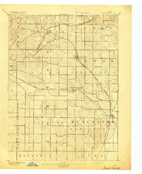
(132)- 1887 Map of Cedar Rapids
 1887 Cedar Rapids1887 Print · USGSLinn and Johnson Counties come alive in this late 19th-century study of the river valleys and rail lines connecting Cedar Rapids to the surrounding prairie. Genealogists can trace old property lines across Jefferson and Big Grove or locate early settlements like Ely and Shueyville.
 - 1888 Map of Amana
 1888 Amana1888 Print · USGSThe Amana Colonies and the Iowa River valley are shown here in the late 1880s, during a period of communal prosperity and rail expansion. Genealogists can trace the specific villages of Hohe Amana, Middle Amana, and Homestead alongside three major railroads.
 - 1889 Map of Amana
 1889 Amana1889 Print · USGSCentral Iowa at the close of the nineteenth century reveals the unique communal settlement of the Amana colonies along the Iowa River. Trace early village footprints from Hohe Amana to Homestead and the rail corridors of the Chicago and Northwestern Railroad.2 unique versions available
 - 1891 Map of Oxford
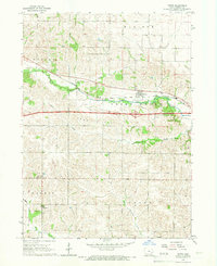
 1891 Oxford1891 Print · USGSEastern Iowa in the late nineteenth century was a landscape of burgeoning rail towns and fertile creek bottoms. Genealogists can trace the early township borders of Oxford and York while following the paths of the Chicago Rock Island and Pacific Railroad and Old Mans Creek.
 - 1891 Map of Mechanicsville
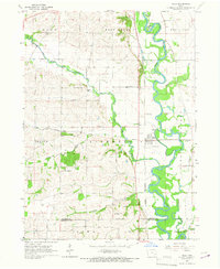
 1891 Mechanicsville1891 Print · USGSEastern Iowa during the late Victorian era is defined here by its emerging rail corridors and the winding path of the Cedar River. Genealogists can trace the early footprints of settlements like Mechanicsville, Mt. Vernon, and Solon before modern development.
 - 1891 Map of Cedar Rapids
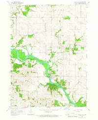
 1891 Cedar Rapids1891 Print · USGSEastern Iowa in the late nineteenth century is a landscape of growing river towns and expanding rail lines. Genealogists and historians can trace the early layout of Cedar Rapids and the development of rail hubs like Ely and Bertram along the Cedar River.2 unique versions available
 - 1891 Map of Iowa City
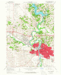
 1891 Iowa City1891 Print · USGSIowa City and its surrounding townships appear at the peak of the late 19th-century rail era. Researchers can trace early railroad alignments like the Chicago Rock Island and Pacific and locate established settlements including Tiffin, Coralville, and South Liberty.3 unique versions available
 - 1894 Map of Mechanicsville
 1894 Mechanicsville1894 Print · USGSEast-central Iowa thrived as a rail and river hub in the 1890s, where major lines connected growing agricultural towns. Researchers can trace the development of Mt. Vernon and Lisbon along the northern tracks or follow the Cedar River to Cedar Bluffs.2 unique versions available
 - 1894 Map of Oxford
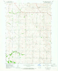
 1894 Oxford1894 Print · USGSNorthwestern Johnson County was a landscape of emerging rail towns and winding creek valleys in the late nineteenth century. Genealogists and local historians can trace the early footprints of Oxford and Windham alongside the Old Mans Creek drainage system.2 unique versions available
 - 1894 Map of West Liberty
 1894 West Liberty1894 Print · USGSEastern Iowa in the late nineteenth century was a landscape of burgeoning rail towns and agricultural hubs. Genealogists and local historians can trace early property boundaries and settlement sites like West Branch, Plato, and the rail junction at West Liberty.2 unique versions available
 - 1899 Map of Amana, 1910 Print
 1899 Amana1910 Print · USGSThe Amana Colonies and the surrounding prairies of Iowa and Benton counties appear here in the decades following their communal establishment. Genealogists and historians can trace the specific layouts of villages like Hohe Amana and Middle Amana or follow the early paths of the Chicago Rock Island and Pacific Railroad.
 - 1901 Map of Stanwood
 1901 Stanwood1901 Print · USGSEastern Iowa is defined by its fertile plains and busy rail corridors at the turn of the century. Genealogists and historians can trace the early layouts of Tipton, West Liberty, and Mt. Vernon, alongside vanished stopping points like Lime City and Walden.2 unique versions available
 - 1903 Map of Fairfax
 1903 Fairfax1903 Print · USGSEastern Iowa's rail-and-river corridor is captured here at the start of the twentieth century, showing the region's transition into an agricultural powerhouse. Genealogists can locate the seven original communal villages of the Amana colonies and old educational sites like Western College.2 unique versions available
 - 1938 Map of Iowa City
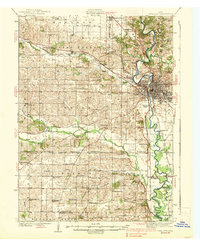 1938 Iowa City1938 Print · USGSIowa City and its surrounding townships are captured in the mid-1930s, revealing a landscape of rural schoolhouses and the early University of Iowa campus. Trace vanished local landmarks like the State Sanatorium, Iowa City Landing Field, and dozens of named country schools.3 unique versions available
 - 1958 Map of Davenport, 1968 Print
 1958 Davenport1968 Print · USGSEastern Iowa and western Illinois thrive along the river during the late fifties, defined by the industrial Quad Cities and a robust rail network. Genealogists can trace family roots through settlements like Oasis and Stanwood or along the Cedar River.2 unique versions available
 - 1961 Map of Davenport
 1961 Davenport1961 Print · USGSThe Quad Cities and the eastern Iowa riverlands are captured here in the early sixties, showing the region's transition into a modern industrial and transit hub. Genealogists and historians can trace the paths of major railroads and find river landmarks like Rock Island Arsenal, Huron Island, and the Coralville Reservoir.
 - 1962 Map of Davenport
 1962 Davenport1962 Print · USGSThe Quad Cities and the Mississippi River corridor are shown at their industrial peak just before the interstate era fully transformed the region. Researchers can trace the sprawling rail networks of the Chicago Rock Island and Pacific and find landmarks like the Rock Island Arsenal and Wild Cat Den State Park.
 - 1965 Map of West Liberty, 1966 Print
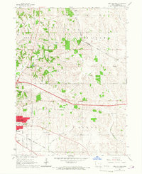
 1965 West Liberty1966 Print · USGSMid-century Muscatine County is centered here on the busy rail junction of West Liberty and the surrounding prairie farmsteads. Researchers can trace family history through numerous rural landmarks like South Prairie Grange Hall, Oak Ridge Cemetery, and the settlement at Downey.
 - 1965 Map of Williamstown, 1966 Print
 1965 Williamstown1966 Print · USGSThe rural borderlands of Johnson and Washington counties are captured here in the mid-1960s, showing a landscape defined by small farms and creek valleys. Researchers can locate numerous local landmarks including St Peters Cem, Hartsock Sch, and the community at Sharon Center.
 - 1965 Map of Tiffin, 1967 Print
 1965 Tiffin1967 Print · USGSTiffin and the surrounding Johnson County farmland are captured here in the mid-sixties as Interstate 80 began to reshape the local landscape. Researchers can trace the Rock Island rail line and locate rural landmarks like Cosgrove and St Peter Dem.2 unique versions available
 - 1965 Map of Cedar Bluff, 1967 Print
 1965 Cedar Bluff1967 Print · USGSCedar County's river valley comes to life in the mid-1960s, showing the rural landscape around Cedar Bluff and the winding Cedar River. Researchers can trace old family roots and transport history at Evergreen Cem, St Bridget Ch, and the lingering Old RR Grade.
 - 1965 Map of Iowa City West, 1967 Print
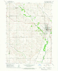
 1965 Iowa City West1967 Print · USGSThe mid-sixties growth of Iowa City and its university is captured here as the Coralville Reservoir reshapes the northern landscape. Trace the footprints of Oakland Cemetery, Penn Sch, and the Cedar Rapids and Iowa City rail line.3 unique versions available
 - 1965 Map of West Liberty SW, 1967 Print
 1965 West Liberty SW1967 Print · USGSJohnson County farmland south of Iowa City is captured here in the mid-1960s, showing a landscape defined by township lines and prairie creeks. Researchers can locate rural landmarks like Scott Cem, Walker Cem, and the Chicago Rock Island and Pacific rail line.
 - 1965 Map of Hills, 1967 Print
 1965 Hills1967 Print · USGSJohnson County in the mid-sixties reveals a river-valley landscape defined by the winding Iowa River and the small-town hub of Hills. Genealogists and local historians can trace family locations near St Stanislaus Ch, Sandtown Cem, and several rural school sites.2 unique versions available
 - 1965 Map of Iowa City East, 1967 Print
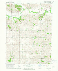
 1965 Iowa City East1967 Print · USGSThe eastern outskirts of Iowa City and rural Johnson County are captured here in the mid-1960s, showing a landscape shaped by rail and agriculture. Researchers can locate numerous vanished country schoolhouses like Railroad Sch and Center Sch, along with the Chicago Rock Island and Pacific rail line.3 unique versions available
Showing maps 1-25 of 132
Top cities of Johnson County
- Iowa City historical maps
- Coralville historical maps
- North Liberty historical maps
- Tiffin historical maps
- Solon historical maps
- Lone Tree historical maps
See more
Frequently asked questions
- What are the different types of historical maps available for Johnson County?
- What is the oldest map of Johnson County?
- Where can I purchase historical maps of Johnson County for my home or office?
- Where can I download high-res historical maps of Johnson County?
- Are there historical topographic maps available for Johnson County?
- Is there historical aerial imagery available for Johnson County?
- Where are historical maps of Johnson County sourced from?