1990s Maps of Johnson County, Iowa
Explore 5 historic maps of Johnson County from the 1990s. These maps offer a rare glimpse into what life looked like during the 1990s — showing old roads, neighborhoods, homes, and landmarks that have changed or disappeared over time.
Whether you're researching your family's past, planning a metal detecting trip, or studying how Johnson County's landscape evolved across the 1990s, these high-resolution maps are a powerful tool for exploring the history of this region.
- Focus on a specific era: All maps on this page are from the 1990s, giving you a focused view of this time period.
- See what’s changed: Compare century-old streets, trails, and buildings to today's modern landscape using overlays and satellite layers.
- Research with precision: Use these maps for genealogy, historical research, land use analysis, or educational projects.
- View, download, or print: Maps are fully viewable online in high resolution, and can be downloaded or printed for your own records.
Start exploring Johnson County's history through authentic maps from the 1990s. This is your window into the past.
Johnson County, IA maps
(5)- 1993 Map of Iowa City East, 1994 Print
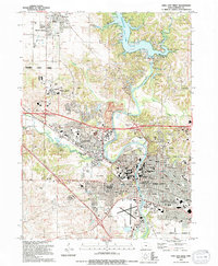
 1993 Iowa City East1994 Print · USGSIowa City and its eastern rural surroundings are documented in the early nineties as suburban expansion met established farmsteads. Genealogists and historians can trace Memory Gardens Cem, the Old Railroad Grade, and the small community of Oasis.
 - 1994 Map of Iowa City West
 1994 Iowa City West1994 Print · USGSThe Iowa City corridor shows rapid academic and civic expansion during the mid-nineties. Researchers can trace historic cemeteries like Oakland Cem, early school sites such as Penn Sch, and the winding Iowa River valley from North Liberty to the Iowa City Municipal Airport.2 unique versions available
 - 1994 Map of Ely
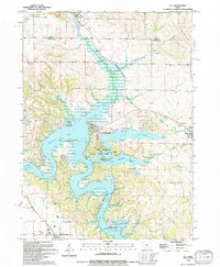 1994 Ely1994 Print · USGSThe reservoir country of Johnson and Linn counties is captured in the mid-nineties, showing the integration of water recreation and town life. Trace family roots at Sulek Cem or follow the Old Railroad Grade through Solon.
 - 1994 Map of Swisher
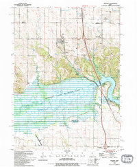 1994 Swisher1994 Print · USGSThe Johnson County river valley and surrounding prairies are captured here in the 1990s as the landscape balances wildlife conservation and rural growth. Researchers can trace numerous family burial grounds including Anderson Cem, Dupont Cem, and Greencastle Cem near the town of Swisher.
 - 1994 Map of Tiffin
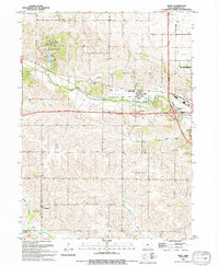 1994 Tiffin1994 Print · USGSIn the early 1990s, Johnson County reveals a transition from traditional rail-and-river geography to modern highway expansion near Tiffin. Genealogists and researchers can trace local roots at St Peter Cem and Oak Hill Cem, or locate landmarks like the Clear Creek-Amana High Sch.
End of results
Showing maps 1-5 of 5
Top cities of Johnson County
- Iowa City historical maps
- Coralville historical maps
- North Liberty historical maps
- Tiffin historical maps
- Solon historical maps
- Lone Tree historical maps
See more
Frequently asked questions
- What are the different types of historical maps available for Johnson County?
- What is the oldest map of Johnson County?
- Where can I purchase historical maps of Johnson County for my home or office?
- Where can I download high-res historical maps of Johnson County?
- Are there historical topographic maps available for Johnson County?
- Is there historical aerial imagery available for Johnson County?
- Where are historical maps of Johnson County sourced from?