1980s Maps of Langworthy, Iowa
Explore 2 historic maps of Langworthy from the 1980s. These maps offer a rare glimpse into what life looked like during the 1980s — showing old roads, neighborhoods, homes, and landmarks that have changed or disappeared over time.
Whether you're researching your family's past, planning a metal detecting trip, or studying how Langworthy's landscape evolved across the 1980s, these high-resolution maps are a powerful tool for exploring the history of this region.
- Focus on a specific era: All maps on this page are from the 1980s, giving you a focused view of this time period.
- See what’s changed: Compare century-old streets, trails, and buildings to today's modern landscape using overlays and satellite layers.
- Research with precision: Use these maps for genealogy, historical research, land use analysis, or educational projects.
- View, download, or print: Maps are fully viewable online in high resolution, and can be downloaded or printed for your own records.
Start exploring Langworthy's history through authentic maps from the 1980s. This is your window into the past.
Langworthy, IA maps
(2)- 1980 Map of Monticello, 1981 Print
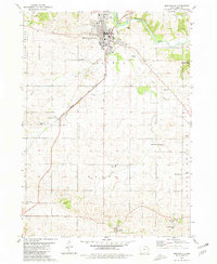 1980 Monticello1981 Print · USGSMonticello and its surrounding townships are captured in the early 1980s, revealing a landscape defined by the river and the rail line. Researchers can trace rural lineages through numerous burial sites and churches, from Oakwood Cem to Edinburg and Zion Ch.
 - 1984 Map of Anamosa, 1985 Print
 1984 Anamosa1985 Print · USGSEastern Iowa's river valleys and farming communities are captured here in the mid-eighties, showing a landscape defined by the Wapsipinicon River and Maquoketa River. Genealogists and historians can locate legacy landmarks like the Independence State Hospital, Ebys Mill, and the State Penal Farm.2 unique versions available
End of results
Showing maps 1-2 of 2
Top cities near Langworthy
- Anamosa historical maps
- Monticello historical maps
- Cascade historical maps
- Springville historical maps
- Olin historical maps
- Hopkinton historical maps
See more
Frequently asked questions
- What are the different types of historical maps available for Langworthy?
- What is the oldest map of Langworthy?
- Where can I purchase historical maps of Langworthy for my home or office?
- Where can I download high-res historical maps of Langworthy?
- Are there historical topographic maps available for Langworthy?
- Is there historical aerial imagery available for Langworthy?
- Where are historical maps of Langworthy sourced from?