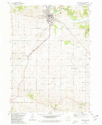
1980 Map of Monticello
USGS Topo · Published 1981About this map
Monticello serves as the central hub of this Iowa landscape, situated where the Chicago Milwaukee St Paul and Pacific railroad crosses the Maquoketa River. The town's layout reflects a classic Midwestern grid, supported by a mix of civic and leisure spaces including a Fairground, a Golf Course, and the Municipal Airport. Outside the main settlement, the land is divided into townships like Lovell, Wayne, and Scotch Grove, characterized by a dense network of family-named cemeteries and rural churches such as Zion Ch and St Johns Ch. Significant local history is preserved in smaller settlements like Langworthy and Edinburg, while the river's path is flanked by Pictured Rocks County Park. For genealogists, the map is particularly useful for locating isolated burial grounds like Four Horn Cem, Kiburz Cem, and Zimmerman Cem scattered across the agricultural sections.
Find a feature on this map
31 named features on this map. Tap any name to fly to it.
Don’t see what you’re looking for? This feature index may not catch every label — zoom into the map to look around manually.
Map Details
Editions of this 1980 Monticello Map
This is the sole edition of this map. No revisions or reprints were ever made.
Other maps of this area

1890 · Anamosa
USGS Topo · 1:62,500

1891 · Monticello
USGS Topo · 1:62,500

1900 · Anamosa
USGS Topo · 1:125,000

1959 · Dubuque
USGS Topo · 1:250,000

1961 · Dubuque
USGS Topo · 1:250,000

1962 · Dubuque
USGS Topo · 1:250,000

1966 · Hopkinton East
USGS Topo · 1:24,000
1966 · Cascade
USGS Topo · 1:24,000
1973 · Anamosa
USGS Topo · 1:24,000
1973 · Hopkinton West
USGS Topo · 1:24,000