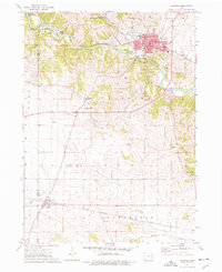
1973 Map of Anamosa
USGS Topo · Published 1977About this map
Anamosa serves as the focal point of this Jones County landscape, characterized by the winding path of the Wapsipinicon River and its junction with Buffalo Creek. The town is notable for its concentration of civic institutions, including the State Reformatory, the hospital, and the county Courthouse. To the west, the historic limestone district of Stone City is marked by numerous quarries, showing the area's geological and industrial foundations. The State Penal Farm occupies a significant portion of the northern river bluffs, while Wapsipinicon State Park preserves the riverfront south of town. Agricultural patterns are evident across the townships of Brown, Fairview, and Greenfield, where rural life is anchored by scattered landmarks such as Forest Chapel, Lerch Airfield, and several small family and parish burial grounds including Boot Hill Cem and Spade Cem.
Find a feature on this map
44 named features on this map. Tap any name to fly to it.
Don’t see what you’re looking for? This feature index may not catch every label — zoom into the map to look around manually.
Map Details
Editions of this 1973 Anamosa Map
This is the sole edition of this map. No revisions or reprints were ever made.
Other maps of this area

1889 · Tipton
USGS Topo · 1:62,500

1890 · Tipton
USGS Topo · 1:62,500

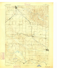
1890 · Anamosa
USGS Topo · 1:62,500
1891 · Monticello
USGS Topo · 1:62,500

1891 · Mechanicsville
USGS Topo · 1:62,500

1894 · Mechanicsville
USGS Topo · 1:62,500

1900 · Anamosa
USGS Topo · 1:125,000

1901 · Stanwood
USGS Topo · 1:125,000

1958 · Davenport
USGS Topo · 1:250,000

1959 · Dubuque
USGS Topo · 1:250,000