1889 Map of Tipton
USGS Topo · Published 1889About this map
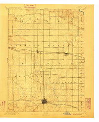
The county seat of Tipton serves as the focal point for this survey conducted by Jno. H. Renshawe and topographer W. J. Peters. Located in the heart of Cedar County, the landscape is defined by the early development of the region's rail infrastructure during the late nineteenth century. The east-west corridor of the Chicago and North-Western Railroad connects the settlements of Mechanicsville, Stanwood, and Clarence, while the Cedar Rapids and Northern Railroad provides the critical north-south link into Tipton.
Find a feature on this map
23 named features on this map. Tap any name to fly to it.
Don’t see what you’re looking for? This feature index may not catch every label — zoom into the map to look around manually.
Map Details
Editions of this 1889 Tipton Map
This is the sole edition of this map. No revisions or reprints were ever made.