
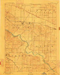
1894 Map of Mechanicsville
USGS Topo · Published 1894About this map
The winding course of the Cedar River dictates the landscape of east-central Iowa in this late nineteenth-century survey, cutting through the corners of Linn, Jones, Cedar, and Johnson counties. The primary corridor of commerce follows the Chicago and North Western Railroad across the northern reaches of the map, linking the established agricultural centers of Mt. Vernon, Lisbon, and Mechanicsville. These rail-side settlements contrast with the smaller river-oriented landings and crossroads, such as the village of Cedar Bluffs.
Find a feature on this map
22 named features on this map. Tap any name to fly to it.
Don’t see what you’re looking for? This feature index may not catch every label — zoom into the map to look around manually.
Map Details
Editions of this 1894 Mechanicsville Map
2 editions found
Other maps of this area

1887 · Cedar Rapids
USGS Topo · 1:62,500

1888 · Marion
USGS Topo · 1:62,500

1889 · Tipton
USGS Topo · 1:62,500

1889 · Marion
USGS Topo · 1:62,500

1890 · Tipton
USGS Topo · 1:62,500

1890 · Anamosa
USGS Topo · 1:62,500

1891 · Monticello
USGS Topo · 1:62,500

1891 · Mechanicsville
USGS Topo · 1:62,500

1891 · Cedar Rapids
USGS Topo · 1:62,500

1891 · Iowa City
USGS Topo · 1:62,500