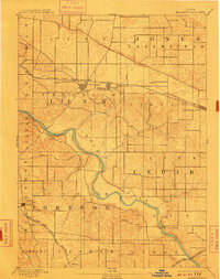
1894 Map of Mechanicsville
USGS Topo · Published 1910About this map
The Cedar River meanders through this landscape at the end of the nineteenth century, carving a path through the intersection of Cedar, Linn, and Johnson counties. The region is defined by a rigorous grid of section lines and townships such as Pioneer and Greenfield, reflecting the organized expansion of Iowa agriculture and commerce. Two primary rail lines dictate the growth of local settlements, with the Chicago and North Western Railroad connecting the northern towns of Mt. Vernon, Lisbon, and Mechanicsville. To the south, the Burlington Cedar Rapids & Northern serves Solon and the small station at Morse. The map shows a transition from the structured street grids of established towns to the riverside bluffs near Cedar Bluffs, illustrating how transportation networks and natural waterways influenced the early development of these eastern Iowa communities.
Find a feature on this map
22 named features on this map. Tap any name to fly to it.
Don’t see what you’re looking for? This feature index may not catch every label — zoom into the map to look around manually.
Map Details
Editions of this 1894 Mechanicsville Map
2 editions found

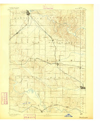
Other maps of this area

1887 · Cedar Rapids
USGS Topo · 1:62,500

1888 · Marion
USGS Topo · 1:62,500

1889 · Tipton
USGS Topo · 1:62,500

1889 · Marion
USGS Topo · 1:62,500

1890 · Tipton
USGS Topo · 1:62,500

1890 · Anamosa
USGS Topo · 1:62,500
1891 · Monticello
USGS Topo · 1:62,500

1891 · Mechanicsville
USGS Topo · 1:62,500

1891 · Cedar Rapids
USGS Topo · 1:62,500

1891 · Iowa City
USGS Topo · 1:62,500