1980s Maps of Richland, Iowa
Explore 4 historic maps of Richland from the 1980s. These maps offer a rare glimpse into what life looked like during the 1980s — showing old roads, neighborhoods, homes, and landmarks that have changed or disappeared over time.
Whether you're researching your family's past, planning a metal detecting trip, or studying how Richland's landscape evolved across the 1980s, these high-resolution maps are a powerful tool for exploring the history of this region.
- Focus on a specific era: All maps on this page are from the 1980s, giving you a focused view of this time period.
- See what’s changed: Compare century-old streets, trails, and buildings to today's modern landscape using overlays and satellite layers.
- Research with precision: Use these maps for genealogy, historical research, land use analysis, or educational projects.
- View, download, or print: Maps are fully viewable online in high resolution, and can be downloaded or printed for your own records.
Start exploring Richland's history through authentic maps from the 1980s. This is your window into the past.
Richland, IA maps
(4)- 1980 Map of Richland, 1981 Print
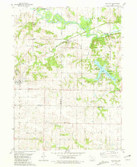 1980 Richland1981 Print · USGSSoutheast Iowa in the early 1980s reveals a landscape of quiet agricultural towns and significant state park land. Researchers can trace family history through several rural burial grounds like Evergreen Cem or follow the rails of the Chicago Milwaukee St Paul and Pacific.
 - 1980 Map of Ollie, 1981 Print
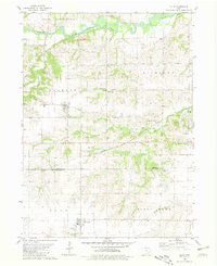 1980 Ollie1981 Print · USGSSoutheast Iowa's farming heartland and rail corridors are preserved here as they appeared in the early eighties. Genealogists and historians can trace family roots through the Ollie Cem, Summit Cem, and Altman Cem while following the Chicago Milwaukee St Paul and Pacific line.
 - 1982 Map of Oskaloosa
 1982 Oskaloosa1982 Print · USGSSoutheast Iowa's river valleys and rail hubs are meticulously detailed in the early eighties, showing a landscape of productive farmland and growing municipal centers. Researchers can trace the legacy of small-town life and local industry through features like Union Mills, What Cheer, and the extensive Burlington Northern rail network.
 - 1984 Map of Muscatine, 1985 Print
 1984 Muscatine1985 Print · USGSThe Mississippi River corridor and Iowa prairie meet in the 1980s, showcasing a landscape of river navigation and agricultural heartland. Genealogists and researchers can locate old schools and landmarks like Maharishi International University, Elm Grove Cem, and Lock & Dam No 16.2 unique versions available
End of results
Showing maps 1-4 of 4
Top cities near Richland
- Fairfield historical maps
- Sigourney historical maps
- Keota historical maps
- Brighton historical maps
- Batavia historical maps
- Maharishi Vedic City historical maps
See more
Frequently asked questions
- What are the different types of historical maps available for Richland?
- What is the oldest map of Richland?
- Where can I purchase historical maps of Richland for my home or office?
- Where can I download high-res historical maps of Richland?
- Are there historical topographic maps available for Richland?
- Is there historical aerial imagery available for Richland?
- Where are historical maps of Richland sourced from?