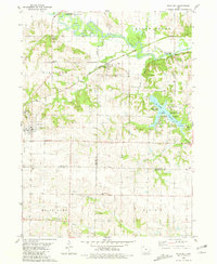
1980 Map of Richland
USGS Topo · Published 1981About this map
Richland serves as the primary hub of this landscape at the intersection of Keokuk, Washington, and Jefferson Counties. To the east, the sprawling waters of Lake Darling and the adjacent Lake Darling State Park dominate the terrain, providing a clear view of mid-century recreational development including a Youth Center and multiple campgrounds. The northern boundary is defined by the winding course of the Skunk River, where the Chicago Milwaukee St Paul and Pacific railroad tracks pass through the small settlement of Rubio.
Find a feature on this map
34 named features on this map. Tap any name to fly to it.
Don’t see what you’re looking for? This feature index may not catch every label — zoom into the map to look around manually.
Map Details
Editions of this 1980 Richland Map
This is the sole edition of this map. No revisions or reprints were ever made.
Other maps of this area

1954 · Des Moines
USGS Topo · 1:250,000

1956 · Des Moines
USGS Topo · 1:250,000

1957 · Des Moines
USGS Topo · 1:250,000

1958 · Davenport
USGS Topo · 1:250,000

1961 · Davenport
USGS Topo · 1:250,000

1962 · Davenport
USGS Topo · 1:250,000

1965 · Harper
USGS Topo · 1:24,000

1969 · Des Moines
USGS Topo · 1:250,000
1973 · Keota
USGS Topo · 1:24,000

1973 · West Chester
USGS Topo · 1:24,000