1970s Maps of Larchwood Township, Iowa
Explore 2 historic maps of Larchwood Township from the 1970s. These maps offer a rare glimpse into what life looked like during the 1970s — showing old roads, neighborhoods, homes, and landmarks that have changed or disappeared over time.
Whether you're researching your family's past, planning a metal detecting trip, or studying how Larchwood Township's landscape evolved across the 1970s, these high-resolution maps are a powerful tool for exploring the history of this region.
- Focus on a specific era: All maps on this page are from the 1970s, giving you a focused view of this time period.
- See what’s changed: Compare century-old streets, trails, and buildings to today's modern landscape using overlays and satellite layers.
- Research with precision: Use these maps for genealogy, historical research, land use analysis, or educational projects.
- View, download, or print: Maps are fully viewable online in high resolution, and can be downloaded or printed for your own records.
Start exploring Larchwood Township's history through authentic maps from the 1970s. This is your window into the past.
Larchwood Township, IA maps
(2)- 1971 Map of Lester, 1973 Print
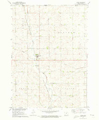 1971 Lester1973 Print · USGSLester and the surrounding northwest Iowa townships are captured here in the early 1970s, as the railroad still dictated the local economy. Genealogists and researchers can locate family sites near Hillside Cem or trace the Burlington Northern line and Mud Creek.
 - 1971 Map of Larchwood, 1973 Print
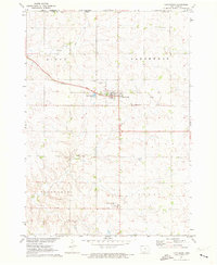 1971 Larchwood1973 Print · USGSThe northern edge of Iowa meets the plains of South Dakota and Minnesota in the early 1970s, centered on the community of Larchwood. Genealogists and local historians can trace the town's layout and its rural surroundings, including St Marys Cem, West Lyon Sch, and the small Zangger Airport.
End of results
Showing maps 1-2 of 2
Top cities near Larchwood Township
- Sioux Falls historical maps
- Brandon historical maps
- Luverne historical maps
- Canton historical maps
- Rock Rapids historical maps
- Inwood historical maps
See more
Top neighborhoods of Larchwood Township
Frequently asked questions
- What are the different types of historical maps available for Larchwood Township?
- What is the oldest map of Larchwood Township?
- Where can I purchase historical maps of Larchwood Township for my home or office?
- Where can I download high-res historical maps of Larchwood Township?
- Are there historical topographic maps available for Larchwood Township?
- Is there historical aerial imagery available for Larchwood Township?
- Where are historical maps of Larchwood Township sourced from?