1970s Maps of Page County, Iowa
Explore 8 historic maps of Page County from the 1970s. These maps offer a rare glimpse into what life looked like during the 1970s — showing old roads, neighborhoods, homes, and landmarks that have changed or disappeared over time.
Whether you're researching your family's past, planning a metal detecting trip, or studying how Page County's landscape evolved across the 1970s, these high-resolution maps are a powerful tool for exploring the history of this region.
- Focus on a specific era: All maps on this page are from the 1970s, giving you a focused view of this time period.
- See what’s changed: Compare century-old streets, trails, and buildings to today's modern landscape using overlays and satellite layers.
- Research with precision: Use these maps for genealogy, historical research, land use analysis, or educational projects.
- View, download, or print: Maps are fully viewable online in high resolution, and can be downloaded or printed for your own records.
Start exploring Page County's history through authentic maps from the 1970s. This is your window into the past.
Page County, IA maps
(8)- 1978 Map of Stanton
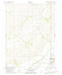
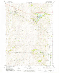 1978 Stanton1978 Print · USGSStanton and the surrounding Montgomery County farmlands are captured in the late 1970s as the regional rail and water networks evolved. Genealogists and local historians can trace legacy sites like Mamre Cem and Arlington Cem or the emerging recreation at Viking Lake State Park.
 - 1978 Map of Shenandoah East
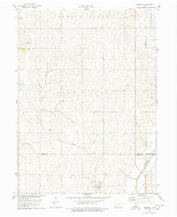
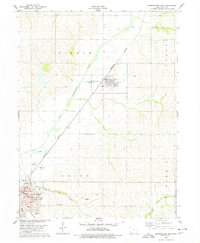 1978 Shenandoah East1978 Print · USGSPage County agriculture and industry are in clear focus in the late 1970s, centered on the river valley and rail lines. Researchers can trace family sites at Rose Hill Cem, locate the Broad St Sch, or follow the Norfolk and Western Old Grade.
 - 1978 Map of Stanton SW
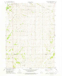
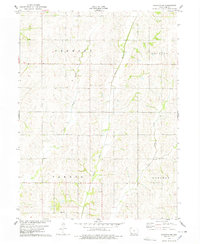 1978 Stanton SW1978 Print · USGSPage County agriculture thrives along the river forks of southwestern Iowa in the late seventies. Family historians can locate rural burial sites such as Baker Cem and Summit Cem set among the townships of Douglas and Tarkio.
 - 1978 Map of Clarinda North
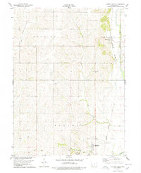 1978 Clarinda North1978 Print · USGSPage County in the late 1970s shows a landscape of steady agricultural rhythm and rural institutional life. Researchers can trace family history at Rose Hill Ch, locate the grounds of the Clarinda Mental Health Institute, and map the Burlington Northern rail corridor.
 - 1978 Map of Shenandoah West
 1978 Shenandoah West1978 Print · USGSShenandoah and the surrounding Iowa farmland are captured during the late seventies as the city expanded westward toward the river. Genealogists and local historians can locate the Mt Calvary Cem, Lowell Ave Sch, and the vintage Drive-in Theater.
 - 1978 Map of Coburg
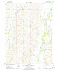 1978 Coburg1978 Print · USGSAgricultural life in southwestern Iowa during the late seventies is centered on the river valleys and rail lines of Montgomery and Page counties. Genealogists and historians can locate old burial grounds like Salem Cem and trace the paths of Coburg and Climax.
 - 1978 Map of Imogene
 1978 Imogene1978 Print · USGSThe rural landscape of Fremont County is captured here in the late seventies, showing the rail-dependent settlement of Imogene and the surrounding farm country. Genealogists can trace family landmarks like Champion Hill Ch, the South Grove Cem, and the path of the Norfolk and Western railroad.
 - 1978 Map of Red Oak South
 1978 Red Oak South1978 Print · USGSSouthern Montgomery County in the late seventies reveals a landscape of structured townships and winding river valleys. Genealogists and local historians can locate rural landmarks like Township Cem, the village of Nyman, and the Old Railroad Grade.
End of results
Showing maps 1-8 of 8
Top cities of Page County
- Clarinda historical maps
- Shenandoah historical maps
- Essex historical maps
- Coin historical maps
- College Springs historical maps
- Shambaugh historical maps
See more
Frequently asked questions
- What are the different types of historical maps available for Page County?
- What is the oldest map of Page County?
- Where can I purchase historical maps of Page County for my home or office?
- Where can I download high-res historical maps of Page County?
- Are there historical topographic maps available for Page County?
- Is there historical aerial imagery available for Page County?
- Where are historical maps of Page County sourced from?