1970s Maps of Poweshiek County, Iowa
Explore 4 historic maps of Poweshiek County from the 1970s. These maps offer a rare glimpse into what life looked like during the 1970s — showing old roads, neighborhoods, homes, and landmarks that have changed or disappeared over time.
Whether you're researching your family's past, planning a metal detecting trip, or studying how Poweshiek County's landscape evolved across the 1970s, these high-resolution maps are a powerful tool for exploring the history of this region.
- Focus on a specific era: All maps on this page are from the 1970s, giving you a focused view of this time period.
- See what’s changed: Compare century-old streets, trails, and buildings to today's modern landscape using overlays and satellite layers.
- Research with precision: Use these maps for genealogy, historical research, land use analysis, or educational projects.
- View, download, or print: Maps are fully viewable online in high resolution, and can be downloaded or printed for your own records.
Start exploring Poweshiek County's history through authentic maps from the 1970s. This is your window into the past.
Poweshiek County, IA maps
(4)- 1979 Map of Montezuma, 1980 Print
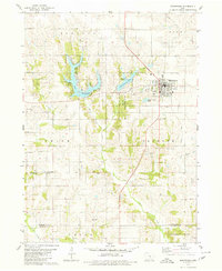 1979 Montezuma1980 Print · USGSMontezuma and its surrounding townships are shown here in the late seventies, just as recreation and conservation areas began to shape the landscape. Researchers can locate several historic burial sites like Twp Cem and Sheley Cem, or trace the shores of Lake Ponderosa.
 - 1979 Map of Searsboro, 1980 Print
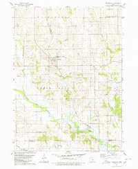 1979 Searsboro1980 Print · USGSPoweshiek and Mahaska counties are captured here in the late seventies, showing the rural landscape around Searsboro and the North Skunk River. Local historians can trace the Chicago and North Western rail line, the Searsboro-Sully-Lynnville Sch, and several family cemeteries.
 - 1979 Map of Grinnell South, 1980 Print
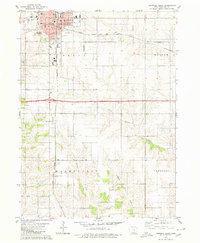 1979 Grinnell South1980 Print · USGSGrinnell and its southern environs appear here in the late seventies, showing the intersection of major rail lines and a growing college town. Genealogists can locate rural landmarks like Upper Blue Point Cem and historic schools such as Bailey Sch or Fairview Sch.
 - 1979 Map of Malcom, 1980 Print
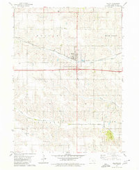 1979 Malcom1980 Print · USGSPoweshiek County's rural character is preserved here in the late seventies, centered on the railroad town of Malcom. Genealogists can trace family plots at Ivy Hill Cem and Ewart Cem or locate the old rail siding at Ewart.
End of results
Showing maps 1-4 of 4
Top cities of Poweshiek County
- Grinnell historical maps
- Brooklyn historical maps
- Montezuma historical maps
- Malcom historical maps
- Deep River historical maps
- Searsboro historical maps
See more
Frequently asked questions
- What are the different types of historical maps available for Poweshiek County?
- What is the oldest map of Poweshiek County?
- Where can I purchase historical maps of Poweshiek County for my home or office?
- Where can I download high-res historical maps of Poweshiek County?
- Are there historical topographic maps available for Poweshiek County?
- Is there historical aerial imagery available for Poweshiek County?
- Where are historical maps of Poweshiek County sourced from?