
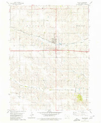
1979 Map of Montezuma
USGS Topo · Published 1980About this map
Montezuma serves as the central hub for this late 1970s survey, surrounded by the agricultural plains and wooded creek beds of Poweshiek County. The landscape is defined by the branching waters of Lake Ponderosa and Diamond Lake, which introduce significant recreational geography to the traditional farming townships of Pleasant and Jackson. This era shows a community balancing established rural roots with new developments, as seen in the expansive Fox Forest County Recreation Area and the local Sig Field. Genealogists will find a high density of burial grounds across the quadrangle, ranging from the Twp Cem and IOOF Cem near the town center to the outlying Beaton Cem and Sheley Cem. Further south, the small settlement of Forest Home sits near the South English River, while the drainage of Moon Creek carves a path through the rolling terrain toward the Mahaska County line.
Find a feature on this map
29 named features on this map. Tap any name to fly to it.
Don’t see what you’re looking for? This feature index may not catch every label — zoom into the map to look around manually.
Map Details
Editions of this 1979 Montezuma Map
This is the sole edition of this map. No revisions or reprints were ever made.
Other maps of this area

1954 · Des Moines
USGS Topo · 1:250,000

1956 · Des Moines
USGS Topo · 1:250,000

1957 · Des Moines
USGS Topo · 1:250,000

1965 · Gibson
USGS Topo · 1:24,000

1968 · Brooklyn
USGS Topo · 1:24,000

1968 · Barnes City
USGS Topo · 1:24,000

1969 · Des Moines
USGS Topo · 1:250,000

1979 · Searsboro
USGS Topo · 1:24,000

1979 · Grinnell South
USGS Topo · 1:24,000
1979 · Malcom
USGS Topo · 1:24,000