1980s Maps of Mount Ayr, Iowa
Explore 3 historic maps of Mount Ayr from the 1980s. These maps offer a rare glimpse into what life looked like during the 1980s — showing old roads, neighborhoods, homes, and landmarks that have changed or disappeared over time.
Whether you're researching your family's past, planning a metal detecting trip, or studying how Mount Ayr's landscape evolved across the 1980s, these high-resolution maps are a powerful tool for exploring the history of this region.
- Focus on a specific era: All maps on this page are from the 1980s, giving you a focused view of this time period.
- See what’s changed: Compare century-old streets, trails, and buildings to today's modern landscape using overlays and satellite layers.
- Research with precision: Use these maps for genealogy, historical research, land use analysis, or educational projects.
- View, download, or print: Maps are fully viewable online in high resolution, and can be downloaded or printed for your own records.
Start exploring Mount Ayr's history through authentic maps from the 1980s. This is your window into the past.
Mount Ayr, IA maps
(3)- 1981 Map of Benton
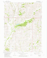 1981 Benton1981 Print · USGSRinggold County in the early eighties shows a rural landscape transitioning between the rail era and modern conservation. Trace the path of the Chicago and North Western line or locate family history near Benton Cem and the settlement of Delphos.
 - 1981 Map of Mount Ayr, 1982 Print
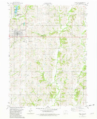 1981 Mount Ayr1982 Print · USGSMount Ayr in the early eighties remains a vital agricultural center defined by the converging forks of the Grand River. Local historians can trace the Old Railroad Grade or locate numerous rural burial sites like Rose Hill Cemetery and Shaha Cem.
 - 1985 Map of Mount Ayr
 1985 Mount Ayr1985 Print · USGSThe Iowa-Missouri borderlands are captured here in the mid-eighties, showing a landscape defined by the branching forks of the Platte River and Grand River. Researchers can trace the heritage of rural communities and conservation sites like Lake of Three Fires State Park and Rose Hill Cemetery.2 unique versions available
End of results
Showing maps 1-3 of 3
Top cities near Mount Ayr
- Grant City historical maps
- Diagonal historical maps
- Kellerton historical maps
- Tingley historical maps
- Shannon City historical maps
- Redding historical maps
See more
Frequently asked questions
- What are the different types of historical maps available for Mount Ayr?
- What is the oldest map of Mount Ayr?
- Where can I purchase historical maps of Mount Ayr for my home or office?
- Where can I download high-res historical maps of Mount Ayr?
- Are there historical topographic maps available for Mount Ayr?
- Is there historical aerial imagery available for Mount Ayr?
- Where are historical maps of Mount Ayr sourced from?