1970s Maps of Ames, Iowa
Explore 4 historic maps of Ames from the 1970s. These maps offer a rare glimpse into what life looked like during the 1970s — showing old roads, neighborhoods, homes, and landmarks that have changed or disappeared over time.
Whether you're researching your family's past, planning a metal detecting trip, or studying how Ames's landscape evolved across the 1970s, these high-resolution maps are a powerful tool for exploring the history of this region.
- Focus on a specific era: All maps on this page are from the 1970s, giving you a focused view of this time period.
- See what’s changed: Compare century-old streets, trails, and buildings to today's modern landscape using overlays and satellite layers.
- Research with precision: Use these maps for genealogy, historical research, land use analysis, or educational projects.
- View, download, or print: Maps are fully viewable online in high resolution, and can be downloaded or printed for your own records.
Start exploring Ames's history through authentic maps from the 1970s. This is your window into the past.
Ames, IA maps
(4)- 1975 Map of Ames West, 1978 Print
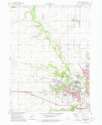 1975 Ames West1978 Print · USGSThe western edges of Ames and the Iowa State University campus are captured here in the mid-seventies, showing the city's expansion toward Ontario. Researchers can trace old school sites like Sawyer Sch, the College Cem, and the path of the Chicago and North Western railroad.2 unique versions available
 - 1975 Map of Huxley, 1978 Print
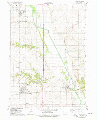 1975 Huxley1978 Print · USGSStory County in the mid-seventies reveals a landscape shaped by the South Skunk River and a dense network of competing railroads. Genealogists can locate several family-anchored sites like Fjelberg Cem, Palestine Ch, and the town of Cambridge.
 - 1975 Map of Slater, 1978 Print
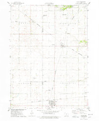 1975 Slater1978 Print · USGSStory County agricultural and rail networks are preserved here in the mid-seventies, showing the intersection of heavy rail lines and academic research. Genealogists and local historians can trace family roots through Bethany Cem or locate old rail spurs like the Chicago Milwaukee St Paul and Pacific near Slater and Kelley.
 - 1975 Map of Ames East, 1978 Print
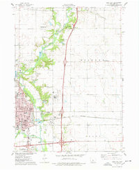 1975 Ames East1978 Print · USGSAmes was expanding along the Skunk River in the mid-1970s, as agricultural research and transit networks shaped the local landscape. Researchers can locate the National Animal Disease Laboratory, the Born Cem, and the tracks of the Chicago and North Western railroad.2 unique versions available
End of results
Showing maps 1-4 of 4
Top cities near Ames
- Ankeny historical maps
- Nevada historical maps
- Polk City historical maps
- Huxley historical maps
- Story City historical maps
- Madrid historical maps
See more
Top neighborhoods of Ames
- Ontario historical maps
- Union Drive historical maps
- Iowa State Center historical maps
- Schilletter-University Village historical maps
- Richardson Court historical maps
- Frederiksen Court historical maps
See more
Frequently asked questions
- What are the different types of historical maps available for Ames?
- What is the oldest map of Ames?
- Where can I purchase historical maps of Ames for my home or office?
- Where can I download high-res historical maps of Ames?
- Are there historical topographic maps available for Ames?
- Is there historical aerial imagery available for Ames?
- Where are historical maps of Ames sourced from?