1970s Maps of Collins Township, Iowa
Explore 4 historic maps of Collins Township from the 1970s. These maps offer a rare glimpse into what life looked like during the 1970s — showing old roads, neighborhoods, homes, and landmarks that have changed or disappeared over time.
Whether you're researching your family's past, planning a metal detecting trip, or studying how Collins Township's landscape evolved across the 1970s, these high-resolution maps are a powerful tool for exploring the history of this region.
- Focus on a specific era: All maps on this page are from the 1970s, giving you a focused view of this time period.
- See what’s changed: Compare century-old streets, trails, and buildings to today's modern landscape using overlays and satellite layers.
- Research with precision: Use these maps for genealogy, historical research, land use analysis, or educational projects.
- View, download, or print: Maps are fully viewable online in high resolution, and can be downloaded or printed for your own records.
Start exploring Collins Township's history through authentic maps from the 1970s. This is your window into the past.
Collins Township, IA maps
(4)- 1975 Map of Mingo, 1978 Print
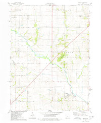 1975 Mingo1978 Print · USGSMid-Iowa's agricultural landscape comes into focus during the 1970s at the junction of Story, Jasper, and Polk counties. Researchers can trace rural genealogy and transport through Mingo, the Old RR Grade at Farrar, and local landmarks like Ashton Ch and Deeter Cem.
 - 1975 Map of Rhodes, 1978 Print
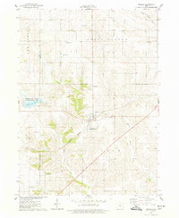 1975 Rhodes1978 Print · USGSRhodes and the surrounding Marshall County farmland are captured in the mid-seventies, showing a landscape defined by rail and river. Genealogists can locate several rural burial grounds including Wilkey Cem, Day Cem, and St Josephs Cem alongside the Chicago Milwaukee St Paul and Pacific tracks.
 - 1975 Map of Baxter, 1978 Print
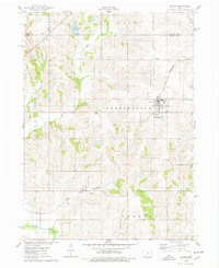 1975 Baxter1978 Print · USGSThe town of Baxter and its surrounding townships are shown here during the mid-1970s, capturing the organized grid of Iowa's agricultural heartland. Genealogists and local historians can locate several rural burial grounds, including Restland Cem and Independence Cem, alongside the CHICAGO AND NORTH WESTERN rail line.
 - 1975 Map of Collins, 1978 Print
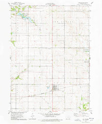 1975 Collins1978 Print · USGSMid-Iowa's agricultural and rail corridor is preserved here during the mid-seventies, centered on the community of Collins. Researchers can trace the path of the Chicago Milwaukee St Paul and Pacific railroad and locate family history at Mound Cem or Collins Cem.
End of results
Showing maps 1-4 of 4
Top cities near Collins Township
- Altoona historical maps
- Newton historical maps
- Bondurant historical maps
- Nevada historical maps
- Colfax historical maps
- State Center historical maps
See more
Top neighborhoods of Collins Township
Frequently asked questions
- What are the different types of historical maps available for Collins Township?
- What is the oldest map of Collins Township?
- Where can I purchase historical maps of Collins Township for my home or office?
- Where can I download high-res historical maps of Collins Township?
- Are there historical topographic maps available for Collins Township?
- Is there historical aerial imagery available for Collins Township?
- Where are historical maps of Collins Township sourced from?