1900s (20th Century) Maps of Allerton, Iowa
Explore 6 historic maps of Allerton from the 1900s (20th Century). These maps offer a rare glimpse into what life looked like during the 1900s — showing old roads, neighborhoods, homes, and landmarks that have changed or disappeared over time.
Whether you're researching your family's past, planning a metal detecting trip, or studying how Allerton's landscape evolved across the 1900s, these high-resolution maps are a powerful tool for exploring the history of this region.
- Focus on a specific era: All maps on this page are from the 1900s, giving you a focused view of this time period.
- See what’s changed: Compare century-old streets, trails, and buildings to today's modern landscape using overlays and satellite layers.
- Research with precision: Use these maps for genealogy, historical research, land use analysis, or educational projects.
- View, download, or print: Maps are fully viewable online in high resolution, and can be downloaded or printed for your own records.
Start exploring Allerton's history through authentic maps from the 1900s. This is your window into the past.
Allerton, IA maps
(6)- 1954 Map of Centerville, 1967 Print
 1954 Centerville1967 Print · USGSThe Iowa-Missouri borderlands at mid-century reveal a landscape shaped by river valleys and the height of the regional rail network. Genealogists and historians can trace the paths of the Wabash railroad and locate old townsites like Mystic, Moulton, and Greentop.3 unique versions available
 - 1957 Map of Centerville
 1957 Centerville1957 Print · USGSThe Iowa-Missouri borderlands in the mid-fifties reveal a landscape of river-valley agriculture and vital rail corridors. Genealogists and historians can trace family-named landmarks and small-town growth in Centerville, Kirksville, and along the Wabash railroad line.
 - 1958 Map of Centerville
 1958 Centerville1958 Print · USGSThe Iowa-Missouri borderlands come into focus during the mid-fifties, showing a landscape defined by river valleys and intersecting rail lines. Genealogists and local historians can trace family roots through dozens of rural hubs like Bloomfield, Unionville, and Corydon.
 - 1964 Map of Allerton, 1966 Print
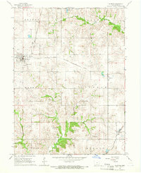 1964 Allerton1966 Print · USGSWayne County farming communities and rail junctions are captured here in the mid-1960s, showing the intersection of major transit lines and rural life. Genealogists can locate several family burial grounds like Sturgeon Cem and Corydon Cem, or trace the tracks of the Chicago Milwaukee St Paul and Pacific through Sewal.
 - 1964 Map of Clio, 1966 Print
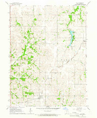 1964 Clio1966 Print · USGSWayne County farmland and the waters of Bob White State Park define this Iowa landscape in the mid-1960s. Genealogists can locate family sites at Hazel Dell Cem and Greenridge Cem along the Rock Island railroad line.
 - 1981 Map of Leon, 1982 Print
 1981 Leon1982 Print · USGSSouthern Iowa and northern Missouri are captured here in the early eighties as the rural landscape balances traditional agriculture with large-scale water management. Researchers can trace the path of the Burlington Northern through Leon or locate early settlements like Decatur City and New Buda.
End of results
Showing maps 1-6 of 6
Top cities near Allerton
- Corydon historical maps
- Humeston historical maps
- Mercer historical maps
- Lineville historical maps
- Derby historical maps
- Promise City historical maps
See more
Frequently asked questions
- What are the different types of historical maps available for Allerton?
- What is the oldest map of Allerton?
- Where can I purchase historical maps of Allerton for my home or office?
- Where can I download high-res historical maps of Allerton?
- Are there historical topographic maps available for Allerton?
- Is there historical aerial imagery available for Allerton?
- Where are historical maps of Allerton sourced from?