1960s Maps of Burnside Township, Iowa
Explore 4 historic maps of Burnside Township from the 1960s. These maps offer a rare glimpse into what life looked like during the 1960s — showing old roads, neighborhoods, homes, and landmarks that have changed or disappeared over time.
Whether you're researching your family's past, planning a metal detecting trip, or studying how Burnside Township's landscape evolved across the 1960s, these high-resolution maps are a powerful tool for exploring the history of this region.
- Focus on a specific era: All maps on this page are from the 1960s, giving you a focused view of this time period.
- See what’s changed: Compare century-old streets, trails, and buildings to today's modern landscape using overlays and satellite layers.
- Research with precision: Use these maps for genealogy, historical research, land use analysis, or educational projects.
- View, download, or print: Maps are fully viewable online in high resolution, and can be downloaded or printed for your own records.
Start exploring Burnside Township's history through authentic maps from the 1960s. This is your window into the past.
Burnside Township, IA maps
(4)- 1965 Map of Fort Dodge South, 1966 Print
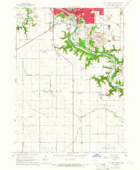 1965 Fort Dodge South1966 Print · USGSSouthern Webster County in the mid-sixties reveals a river-driven landscape where industry meets the prairie. Genealogists and historians can trace the foundations of Coalville and Kalo or locate family sites at Elkhorn Cem and Graceland Cem.
 - 1965 Map of Lehigh, 1966 Print
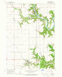 1965 Lehigh1966 Print · USGSWebster County in the mid-1960s displays a landscape of river-bend settlements and deep ravines along the Des Moines River. Researchers can trace the rail corridor of the Chicago and North Western and locate family burial sites at West Lawn Cem or Township Cem.
 - 1965 Map of Harcourt, 1966 Print
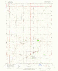 1965 Harcourt1966 Print · USGSWebster County agriculture and rail transport meet in the mid-1960s as these prairie townships expand their drainage and transit networks. Trace the intersections of the Chicago and North Western through Harcourt or locate the Lost Grove Cem and small sidings like Lundgren.2 unique versions available
 - 1965 Map of Evanston, 1966 Print
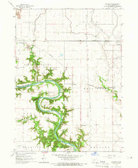 1965 Evanston1966 Print · USGSWebster County's river valleys and rail lines are captured here in the mid-sixties, showing the rural landscape before modern development. Genealogists and historians can locate old settlements like Border Plains and Evanston, or trace the OLD RAILROAD GRADE near the river.
End of results
Showing maps 1-4 of 4
Top cities near Burnside Township
- Fort Dodge historical maps
- Gowrie historical maps
- Dayton historical maps
- Stratford historical maps
- Coalville historical maps
- Otho historical maps
See more
Top neighborhoods of Burnside Township
Frequently asked questions
- What are the different types of historical maps available for Burnside Township?
- What is the oldest map of Burnside Township?
- Where can I purchase historical maps of Burnside Township for my home or office?
- Where can I download high-res historical maps of Burnside Township?
- Are there historical topographic maps available for Burnside Township?
- Is there historical aerial imagery available for Burnside Township?
- Where are historical maps of Burnside Township sourced from?