1960s Maps of Elkhorn Township, Iowa
Explore 2 historic maps of Elkhorn Township from the 1960s. These maps offer a rare glimpse into what life looked like during the 1960s — showing old roads, neighborhoods, homes, and landmarks that have changed or disappeared over time.
Whether you're researching your family's past, planning a metal detecting trip, or studying how Elkhorn Township's landscape evolved across the 1960s, these high-resolution maps are a powerful tool for exploring the history of this region.
- Focus on a specific era: All maps on this page are from the 1960s, giving you a focused view of this time period.
- See what’s changed: Compare century-old streets, trails, and buildings to today's modern landscape using overlays and satellite layers.
- Research with precision: Use these maps for genealogy, historical research, land use analysis, or educational projects.
- View, download, or print: Maps are fully viewable online in high resolution, and can be downloaded or printed for your own records.
Start exploring Elkhorn Township's history through authentic maps from the 1960s. This is your window into the past.
Elkhorn Township, IA maps
(2)- 1965 Map of Moorland, 1966 Print
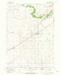 1965 Moorland1966 Print · USGSMoorland was a vital rail crossroads in the mid-1960s, where three major lines intersected amidst the fertile Iowa prairie. Researchers can trace family history at Our Lady of Good Council Cem or locate the small settlement of Roelyn and the Nepler Landing Field.
 - 1965 Map of Fort Dodge South, 1966 Print
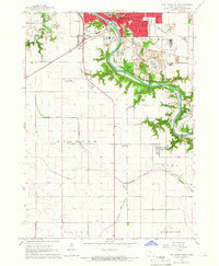 1965 Fort Dodge South1966 Print · USGSSouthern Webster County in the mid-sixties reveals a river-driven landscape where industry meets the prairie. Genealogists and historians can trace the foundations of Coalville and Kalo or locate family sites at Elkhorn Cem and Graceland Cem.
End of results
Showing maps 1-2 of 2
Top cities near Elkhorn Township
- Fort Dodge historical maps
- Gowrie historical maps
- Dayton historical maps
- Coalville historical maps
- Badger historical maps
- Otho historical maps
See more
Top neighborhoods of Elkhorn Township
Frequently asked questions
- What are the different types of historical maps available for Elkhorn Township?
- What is the oldest map of Elkhorn Township?
- Where can I purchase historical maps of Elkhorn Township for my home or office?
- Where can I download high-res historical maps of Elkhorn Township?
- Are there historical topographic maps available for Elkhorn Township?
- Is there historical aerial imagery available for Elkhorn Township?
- Where are historical maps of Elkhorn Township sourced from?