1960s Maps of Sioux City, Iowa
Explore 6 historic maps of Sioux City from the 1960s. These maps offer a rare glimpse into what life looked like during the 1960s — showing old roads, neighborhoods, homes, and landmarks that have changed or disappeared over time.
Whether you're researching your family's past, planning a metal detecting trip, or studying how Sioux City's landscape evolved across the 1960s, these high-resolution maps are a powerful tool for exploring the history of this region.
- Focus on a specific era: All maps on this page are from the 1960s, giving you a focused view of this time period.
- See what’s changed: Compare century-old streets, trails, and buildings to today's modern landscape using overlays and satellite layers.
- Research with precision: Use these maps for genealogy, historical research, land use analysis, or educational projects.
- View, download, or print: Maps are fully viewable online in high resolution, and can be downloaded or printed for your own records.
Start exploring Sioux City's history through authentic maps from the 1960s. This is your window into the past.
Sioux City, IA maps
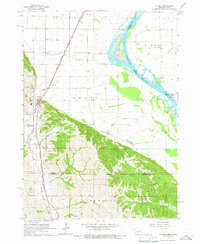
(6)- 1963 Map of Sioux City South, 1964 Print
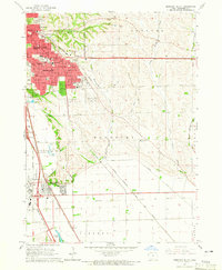
 1963 Sioux City South1964 Print · USGSThe tri-state river junction between Nebraska, Iowa, and South Dakota hums with mid-century activity along the Missouri and Big Sioux Rivers. Genealogists can trace old family roots at Salem Ch, St Michaels Cem, or the rural Hileman Sch.4 unique versions available
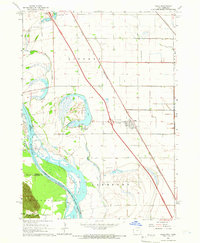
 - 1963 Map of Sioux City North, 1964 Print
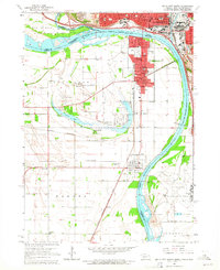
 1963 Sioux City North1964 Print · USGSThe northern reaches of Sioux City and Riverside are captured in the early sixties as urban development meets the rugged Loess Hills. Researchers can find precise locations for Briar Cliff College, Logan Park Cemetery, and the old Soos Speedway.3 unique versions available
 - 1964 Map of Sergeant Bluff, 1965 Print
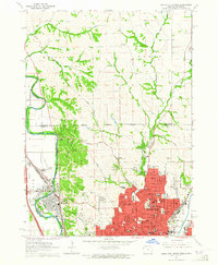
 1964 Sergeant Bluff1965 Print · USGSSioux City and Sergeant Bluff are captured during a decade of significant suburban and institutional growth in the mid-1960s. Researchers can trace the development of Morningside College, find family plots in Graceland Park Cemetery, or locate old landmarks like Redeemer Chapel.3 unique versions available
 - 1964 Map of James, 1965 Print
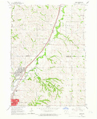 1964 James1965 Print · USGSThe Floyd River valley north of Sioux City shows a landscape of rail-driven transit and suburban growth in the early sixties. Genealogists and local historians can trace the rural roots of Hungerford through Hungerford Cem and the Grant Sch.3 unique versions available
 - 1964 Map of Homer, 1966 Print
 1964 Homer1966 Print · USGSNear the Missouri River in the mid-1960s, this area of Dakota County reveals a landscape shaped by the Winnebago reservation and the rail lines. Genealogists and local historians can trace the community of Homer alongside St Cornelius Cem, Omaha Valley Cem, and the old Combs Sch.2 unique versions available
 - 1964 Map of Salix, 1966 Print
 1964 Salix1966 Print · USGSThe Missouri River bottomlands of Woodbury County are captured here in the mid-sixties as the Interstate era reached the region. Researchers can trace family history at St Josephs Cem or explore the river-driven geography of Browns Lake and the Winnebago Indian Reservation Boundary.2 unique versions available
End of results
Showing maps 1-6 of 6
Top cities near Sioux City
- South Sioux City historical maps
- Sergeant Bluff historical maps
- Dakota Dunes historical maps
- North Sioux City historical maps
- Dakota City historical maps
- Sloan historical maps
See more
Top neighborhoods of Sioux City
Frequently asked questions
- What are the different types of historical maps available for Sioux City?
- What is the oldest map of Sioux City?
- Where can I purchase historical maps of Sioux City for my home or office?
- Where can I download high-res historical maps of Sioux City?
- Are there historical topographic maps available for Sioux City?
- Is there historical aerial imagery available for Sioux City?
- Where are historical maps of Sioux City sourced from?