1960s Maps of Wingate, Kansas
Explore 1 historic maps of Wingate from the 1960s. These maps offer a rare glimpse into what life looked like during the 1960s — showing old roads, neighborhoods, homes, and landmarks that have changed or disappeared over time.
Whether you're researching your family's past, planning a metal detecting trip, or studying how Wingate's landscape evolved across the 1960s, these high-resolution maps are a powerful tool for exploring the history of this region.
- Focus on a specific era: All maps on this page are from the 1960s, giving you a focused view of this time period.
- See what’s changed: Compare century-old streets, trails, and buildings to today's modern landscape using overlays and satellite layers.
- Research with precision: Use these maps for genealogy, historical research, land use analysis, or educational projects.
- View, download, or print: Maps are fully viewable online in high resolution, and can be downloaded or printed for your own records.
Start exploring Wingate's history through authentic maps from the 1960s. This is your window into the past.
Wingate, KS maps
(1)- 1964 Map of Cambridge NW, 1965 Print
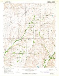 1964 Cambridge NW1965 Print · USGSCowley County in the mid-1960s was a landscape where energy production met traditional ranching along the Old Indian Treaty Boundary. Genealogists and historians can locate the Timber Creek Cem, trace the St Louis and San Francisco rail line, and find the Mt Vernon Cem.2 unique versions available
End of results
Showing maps 1-1 of 1
Top cities near Wingate
- Winfield historical maps
- Leon historical maps
- Bloomington historical maps
- Burden historical maps
- Atlanta historical maps
- Latham historical maps
See more
Frequently asked questions
- What are the different types of historical maps available for Wingate?
- What is the oldest map of Wingate?
- Where can I purchase historical maps of Wingate for my home or office?
- Where can I download high-res historical maps of Wingate?
- Are there historical topographic maps available for Wingate?
- Is there historical aerial imagery available for Wingate?
- Where are historical maps of Wingate sourced from?