1960s Maps of Burden, Kansas
Explore 2 historic maps of Burden from the 1960s. These maps offer a rare glimpse into what life looked like during the 1960s — showing old roads, neighborhoods, homes, and landmarks that have changed or disappeared over time.
Whether you're researching your family's past, planning a metal detecting trip, or studying how Burden's landscape evolved across the 1960s, these high-resolution maps are a powerful tool for exploring the history of this region.
- Focus on a specific era: All maps on this page are from the 1960s, giving you a focused view of this time period.
- See what’s changed: Compare century-old streets, trails, and buildings to today's modern landscape using overlays and satellite layers.
- Research with precision: Use these maps for genealogy, historical research, land use analysis, or educational projects.
- View, download, or print: Maps are fully viewable online in high resolution, and can be downloaded or printed for your own records.
Start exploring Burden's history through authentic maps from the 1960s. This is your window into the past.
Burden, KS maps
(2)- 1962 Map of Cambridge, 1963 Print
 1962 Cambridge1963 Print · USGSIn the early 1960s, this Cowley County landscape was a quiet hub of the Atchison Topeka and Santa Fe railroad. Local historians can trace the foundations of Cambridge and locate rural burial grounds like Windsor Cem and Grand Prairie Cem.
 - 1964 Map of Burden, 1966 Print
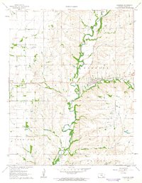
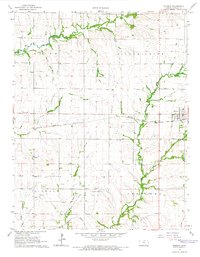 1964 Burden1966 Print · USGSCowley County in the mid-1960s was a bustling intersection of rail transport and Kansas energy production. Genealogists and historians can trace family roots through New Salem Cem and Tisdale Cem or follow the paths of the Atchison Topeka and Santa Fe and Missouri Pacific railroads.3 unique versions available
End of results
Showing maps 1-2 of 2
Top cities near Burden
- Winfield historical maps
- Dexter historical maps
- Tisdale historical maps
- Atlanta historical maps
- Latham historical maps
- Cambridge historical maps
Frequently asked questions
- What are the different types of historical maps available for Burden?
- What is the oldest map of Burden?
- Where can I purchase historical maps of Burden for my home or office?
- Where can I download high-res historical maps of Burden?
- Are there historical topographic maps available for Burden?
- Is there historical aerial imagery available for Burden?
- Where are historical maps of Burden sourced from?