Old Maps of Cowley County, Kansas for Genealogy
Trace your family roots with 192 historic maps of Cowley County. These high-res maps reveal old neighborhoods, homesites, landmarks, and streets — helping you uncover where your ancestors lived and how the area evolved over time.
- Explore historic neighborhoods: Identify where your relatives may have lived in the 1800s or 1900s.
- Compare maps over time: Trace the changes in streets, buildings, and landmarks for multi-generational research.
- Perfect for genealogy & ancestry research: Used by family historians and researchers to map out lineage and migration.
These maps are an incredible resource for exploring your personal connection to Cowley County's past.
Cowley County, KS maps
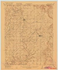
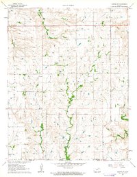
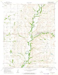
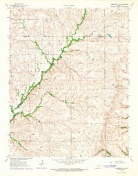
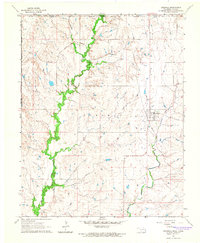
(192)- 1889 Map of Burden
 1889 Burden1889 Print · USGSCowley County was at the height of its railroad-driven expansion in the 1880s, becoming a vital corridor for three major lines. Researchers can trace the early layouts of Winfield, Burden, and Dexter alongside long-lost railroad stops like Torrance.6 unique versions available
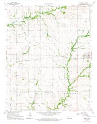
 - 1890 Map of Wellington
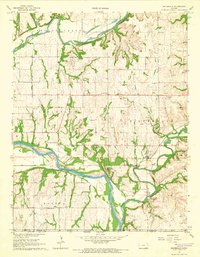
 1890 Wellington1890 Print · USGSSumner and Cowley counties are captured here in the late nineteenth century as a dense network of railroads and river towns transformed the Kansas prairie. Genealogists and historians can trace the early layouts of Wellington, Oxford, and Geuda Springs before the turn of the century.6 unique versions available
 - 1916 Map of Foraker
 1916 Foraker1916 Print · USGSNorthern Osage County is captured here just before the First World War, showing the ranching and rail landscape of the Oklahoma-Kansas border. Family historians can locate rural landmarks like Red Eagle School, Grainola, and the Midland Valley railroad.2 unique versions available
 - 1935 Map of Kaw
 1935 Kaw1935 Print · USGSNorthern Oklahoma's river valleys and rural school districts are captured here in the mid-1930s as the Santa Fe railroad shaped the local economy. Researchers can trace vanished rural hubs and landmarks like Chilocco, Maple Grove Ch, and Uncas.2 unique versions available
 - 1955 Map of Udall, 1956 Print
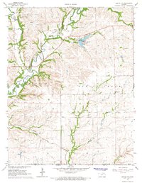
 1955 Udall1956 Print · USGSCowley County in the mid-fifties is a landscape of river bends and rural crossroads during a time of active petroleum exploration and rail travel. Researchers can locate country schools like Red Bud Sch, the tracks of the Atchison Topeka and Santa Fe, and the Old Indian Boundary.2 unique versions available
 - 1955 Map of Mulvane, 1956 Print
 1955 Mulvane1956 Print · USGSThe rail-and-river landscape surrounding mid-century Mulvane is captured here at the intersection of four Kansas counties. Researchers can trace the original Atchison Topeka and Santa Fe corridor and locate local landmarks like Littleton Cem and Central Sch.
 - 1955 Map of Wichita, 1959 Print
 1955 Wichita1959 Print · USGSSouth-central Kansas comes alive in the mid-1950s as Wichita grows into its role as a regional industrial and military powerhouse. Trace the rail-and-river network connecting El Dorado and Arkansas City through the Atchison Topeka and Santa Fe lines.3 unique versions available
 - 1955 Map of Enid, 1966 Print
 1955 Enid1966 Print · USGSNorth-central Oklahoma's transition from open plains to the blackjack hills of the Osage Indian Reservation is captured in the mid-1950s. Researchers can trace the development of the Naval Reserve Oil Field, the grounds of Vance AFB, and the early footprints of Tulsa and Stillwater.4 unique versions available
 - 1958 Map of Enid
 1958 Enid1958 Print · USGSNorthern Oklahoma is mapped here in the late fifties, showcasing a dense network of petroleum production and historic tribal lands. Researchers can trace the legacy of the Osage Indian Reservation, early energy hubs like the Cushing Oil Field, and the Chilocco Indian Agricultural School.2 unique versions available
 - 1958 Map of Wichita
 1958 Wichita1958 Print · USGSSouth Central Kansas in the late fifties was a landscape of aviation industry, oil exploration, and expanding turnpikes. Researchers can trace mid-century growth through McConnell Air Force Base, major facilities for Cessna Aircraft Company, and the active El Dorado Oil Field.
 - 1962 Map of Cedar Vale West, 1963 Print
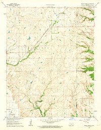
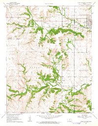 1962 Cedar Vale West1963 Print · USGSCowley County in the early 1960s reveals a landscape shaped by rail, ranching, and the legacy of the Old Indian Treaty Boundary. Genealogists and historians can trace family roots through the Cedar Creek Cem or locate the industrial footprint of local Oil Wells and the Missouri Pacific line.2 unique versions available
 - 1962 Map of Dexter SW, 1963 Print
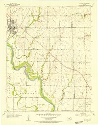
 1962 Dexter SW1963 Print · USGSCowley County was a landscape of remote prairie schoolhouses and creek-side agriculture in the early sixties. Genealogists and historians can trace local roots at the Patton Cem or locate the site of the Otto Sch along the banks of Spring Creek.
 - 1962 Map of Grand Summit, 1963 Print
 1962 Grand Summit1963 Print · USGSThe Flint Hills on the Cowley and Elk County border appear here in the early sixties, defined by cattle country and energy production. Genealogists and researchers can locate Gospel Ridge Cem and trace the Atchison Topeka and Santa Fe rail line through Grand Summit.2 unique versions available
 - 1962 Map of Dexter, 1963 Print
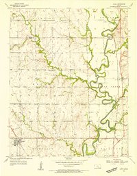
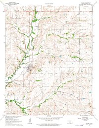 1962 Dexter1963 Print · USGSCowley County, Kansas, is captured in the early sixties as the Missouri Pacific railroad winds through the Grouse Creek valley. Genealogists and researchers can trace the small communities of Dexter and Hooser alongside a local Cem and Quarry.
 - 1962 Map of Dexter NE, 1963 Print
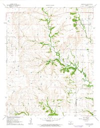 1962 Dexter NE1963 Print · USGSSoutheastern Kansas ranching country is meticulously detailed in the early 1960s as it transitions into a modern era of agriculture. Researchers can locate specific family landmarks such as the Boone Ranch, McCoy Ranch, and a small local Cem.2 unique versions available
 - 1962 Map of Cambridge, 1963 Print
 1962 Cambridge1963 Print · USGSIn the early 1960s, this Cowley County landscape was a quiet hub of the Atchison Topeka and Santa Fe railroad. Local historians can trace the foundations of Cambridge and locate rural burial grounds like Windsor Cem and Grand Prairie Cem.
 - 1963 Map of Kaw City NW, 1965 Print
 1963 Kaw City NW1965 Print · USGSThe Oklahoma-Kansas borderlands in the early 1960s were defined by the winding Arkansas River and a network of rural community hubs. Researchers can locate vanished landmarks like Tipton Community Hall, School No 106, and the family history preserved at Cooper Cem.
 - 1964 Map of Cambridge NW, 1965 Print
 1964 Cambridge NW1965 Print · USGSCowley County in the mid-1960s was a landscape where energy production met traditional ranching along the Old Indian Treaty Boundary. Genealogists and historians can locate the Timber Creek Cem, trace the St Louis and San Francisco rail line, and find the Mt Vernon Cem.2 unique versions available
 - 1964 Map of Hardy, 1965 Print
 1964 Hardy1965 Print · USGSNorthern Oklahoma and the Kansas borderlands appear in the mid-sixties as a landscape of rural creek valleys and reservation boundaries. Researchers can trace the Midland Valley terrain and locate local landmarks like the Hardy settlement and the Radio Tower.2 unique versions available
 - 1964 Map of Cambridge NE, 1965 Print
 1964 Cambridge NE1965 Print · USGSThe Flint Hills of Cowley County were a hive of mid-century petroleum activity and ranching during the 1960s. Researchers can trace historical markers like the Old Indian Treaty Boundary, the Glen Grouse Cem, and the rail path of the Atchison Topeka and Santa Fe.
 - 1964 Map of Burden, 1966 Print
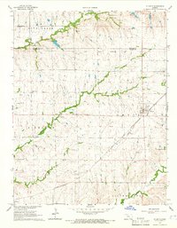
 1964 Burden1966 Print · USGSCowley County in the mid-1960s was a bustling intersection of rail transport and Kansas energy production. Genealogists and historians can trace family roots through New Salem Cem and Tisdale Cem or follow the paths of the Atchison Topeka and Santa Fe and Missouri Pacific railroads.3 unique versions available
 - 1964 Map of Maple City, 1966 Print
 1964 Maple City1966 Print · USGSThe Kansas-Oklahoma borderlands in the mid-1960s reveal a landscape of heavy industry and prairie heritage. Researchers can trace the Old Indian Treaty Boundary and explore the rail-side life of Vinton or the Albright Oil Field.
 - 1964 Map of Atlanta, 1966 Print
 1964 Atlanta1966 Print · USGSThe town of Atlanta and the surrounding Kansas prairie are captured here during the mid-sixties, a period defined by established rail lines and active oil fields. Genealogists and historians can trace the Old Indian Treaty Boundary or locate rural landmarks like Prairie View Ch and the St Louis San Francisco rail corridor.
 - 1964 Map of Grainola, 1966 Print
 1964 Grainola1966 Print · USGSOsage County territory during the mid-sixties reveals a landscape defined by ranching and early petroleum development within the Foraker Indian Reservation. Trace the legacy of small settlements like Grainola and Frankfort alongside the Frankfort Oil Field.2 unique versions available
 - 1965 Map of Silverdale, 1966 Print
 1965 Silverdale1966 Print · USGSSouthern Cowley County comes into focus in the mid-sixties, where the Arkansas River meets an landscape of limestone quarries and old treaty lines. Genealogists and local historians can locate family landmarks like Parker Cem, Grandview Ch, and the Old Indian Treaty Boundary.
Showing maps 1-25 of 192
Top cities of Cowley County
- Winfield historical maps
- Arkansas City historical maps
- Udall historical maps
- Burden historical maps
- Parkerfield historical maps
- Dexter historical maps
See more
Frequently asked questions
- What are the different types of historical maps available for Cowley County?
- What is the oldest map of Cowley County?
- Where can I purchase historical maps of Cowley County for my home or office?
- Where can I download high-res historical maps of Cowley County?
- Are there historical topographic maps available for Cowley County?
- Is there historical aerial imagery available for Cowley County?
- Where are historical maps of Cowley County sourced from?