1940s Maps of Douglas County, Kansas
Explore 3 historic maps of Douglas County from the 1940s. These maps offer a rare glimpse into what life looked like during the 1940s — showing old roads, neighborhoods, homes, and landmarks that have changed or disappeared over time.
Whether you're researching your family's past, planning a metal detecting trip, or studying how Douglas County's landscape evolved across the 1940s, these high-resolution maps are a powerful tool for exploring the history of this region.
- Focus on a specific era: All maps on this page are from the 1940s, giving you a focused view of this time period.
- See what’s changed: Compare century-old streets, trails, and buildings to today's modern landscape using overlays and satellite layers.
- Research with precision: Use these maps for genealogy, historical research, land use analysis, or educational projects.
- View, download, or print: Maps are fully viewable online in high resolution, and can be downloaded or printed for your own records.
Start exploring Douglas County's history through authentic maps from the 1940s. This is your window into the past.
Douglas County, KS maps
(3)- 1947 Map of Lawrence, 1954 Print
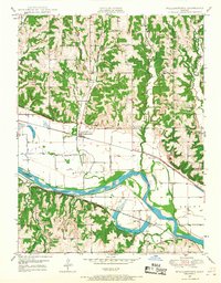
 1947 Lawrence1954 Print · USGSEastern Kansas and western Missouri thrive in the late 1940s, showing a landscape defined by major river valleys and a dense railway network. Genealogists can trace family settlements from Lawrence to Greenwood and locate landmarks like Olathe Navy and Lake Lotawana.
 - 1949 Map of Williamstown, 1967 Print
 1949 Williamstown1967 Print · USGSMid-century Jefferson County remains deeply agricultural as the river and rails dictate the local economy. Genealogists and historians can trace family roots through numerous country schools like Clover Hill Sch and legacy sites such as Underwood Cem.3 unique versions available
 - 1949 Map of Perry, 1968 Print
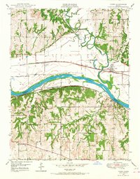 1949 Perry1968 Print · USGSIn the late 1940s, the river valleys of Jefferson and Douglas Counties remained a crossroads of rail and river commerce. Genealogists can trace family names and rural sites like Mt Calvary Cem, Big Springs, and the Young Sch along the river bluffs.4 unique versions available
End of results
Showing maps 1-3 of 3
Top cities of Douglas County
- Lawrence historical maps
- Eudora historical maps
- Baldwin City historical maps
- Kanwaka Township historical maps
- Lecompton historical maps
- Clinton historical maps
Frequently asked questions
- What are the different types of historical maps available for Douglas County?
- What is the oldest map of Douglas County?
- Where can I purchase historical maps of Douglas County for my home or office?
- Where can I download high-res historical maps of Douglas County?
- Are there historical topographic maps available for Douglas County?
- Is there historical aerial imagery available for Douglas County?
- Where are historical maps of Douglas County sourced from?