1980s Maps of Douglas County, Kansas
Explore 2 historic maps of Douglas County from the 1980s. These maps offer a rare glimpse into what life looked like during the 1980s — showing old roads, neighborhoods, homes, and landmarks that have changed or disappeared over time.
Whether you're researching your family's past, planning a metal detecting trip, or studying how Douglas County's landscape evolved across the 1980s, these high-resolution maps are a powerful tool for exploring the history of this region.
- Focus on a specific era: All maps on this page are from the 1980s, giving you a focused view of this time period.
- See what’s changed: Compare century-old streets, trails, and buildings to today's modern landscape using overlays and satellite layers.
- Research with precision: Use these maps for genealogy, historical research, land use analysis, or educational projects.
- View, download, or print: Maps are fully viewable online in high resolution, and can be downloaded or printed for your own records.
Start exploring Douglas County's history through authentic maps from the 1980s. This is your window into the past.
Douglas County, KS maps
(2)- 1983 Map of Grantville, 1984 Print
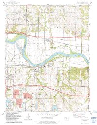 1983 Grantville1984 Print · USGSThe Kansas River valley east of Topeka shows a landscape of busy rail lines and river islands in the early 1980s. Researchers can locate specific family history sites like Grantville Cem, North Fairview Sch, and the riverside settlement of Tecumseh.
 - 1983 Map of Lawrence, 1984 Print
 1983 Lawrence1984 Print · USGSEastern Kansas in the early eighties shows a landscape of growing reservoirs and historic rail towns. Genealogists and historians can trace routes through Topeka and Ottawa, or locate smaller sites like Highland Cem and the settlement of Vassar.
End of results
Showing maps 1-2 of 2
Top cities of Douglas County
- Lawrence historical maps
- Eudora historical maps
- Baldwin City historical maps
- Kanwaka Township historical maps
- Lecompton historical maps
- Clinton historical maps
Frequently asked questions
- What are the different types of historical maps available for Douglas County?
- What is the oldest map of Douglas County?
- Where can I purchase historical maps of Douglas County for my home or office?
- Where can I download high-res historical maps of Douglas County?
- Are there historical topographic maps available for Douglas County?
- Is there historical aerial imagery available for Douglas County?
- Where are historical maps of Douglas County sourced from?