1900s (20th Century) Maps of Gove County, Kansas
Explore 39 historic maps of Gove County from the 1900s (20th Century). These maps offer a rare glimpse into what life looked like during the 1900s — showing old roads, neighborhoods, homes, and landmarks that have changed or disappeared over time.
Whether you're researching your family's past, planning a metal detecting trip, or studying how Gove County's landscape evolved across the 1900s, these high-resolution maps are a powerful tool for exploring the history of this region.
- Focus on a specific era: All maps on this page are from the 1900s, giving you a focused view of this time period.
- See what’s changed: Compare century-old streets, trails, and buildings to today's modern landscape using overlays and satellite layers.
- Research with precision: Use these maps for genealogy, historical research, land use analysis, or educational projects.
- View, download, or print: Maps are fully viewable online in high resolution, and can be downloaded or printed for your own records.
Start exploring Gove County's history through authentic maps from the 1900s. This is your window into the past.
Gove County, KS maps
(39)- 1939 Map of Sandon, 1959 Print
 1939 Sandon1959 Print · USGSWestern Kansas at the end of the 1930s reveals a landscape of remote schoolhouses and deep canyons along the Ladder Creek drainage. Genealogists and local historians can trace rural landmarks like Zanobia Sch, the Pueblo Ruins Monument, and the settlement of Sandon along the Missouri Pacific tracks.
 - 1942 Map of Sandon
 1942 Sandon1942 Print · USGSWestern Kansas at the end of the Depression era reveals a landscape shaped by both deep canyon drainages and the arrival of organized recreation and preservation. Genealogists can locate family-named landmarks and rural school sites like Goodluck Sch and Zanobia Sch, or trace the historical Pueblo Ruins Monument near McBride.
 - 1954 Map of Goodland, 1976 Print
 1954 Goodland1976 Print · USGSNorthwest Kansas comes into focus during the mid-1950s, showing a landscape defined by its vital river forks and thriving rail towns. Researchers can trace the path of the Union Pacific through Colby or locate historic parks like Sheridan Co State Park.
 - 1955 Map of Scott City, 1969 Print
 1955 Scott City1969 Print · USGSWestern Kansas in the mid-fifties is captured here as a landscape of rural schoolhouses and significant rail corridors. Family historians can trace the locations of Skyline and Beaver Creek Schools or follow the Union Pacific line through Oakley and Sharon Springs.4 unique versions available
 - 1956 Map of Goodland
 1956 Goodland1956 Print · USGSThe high plains of Northwest Kansas in the mid-fifties reveal a landscape of river-fed agriculture and expanding rail networks. Genealogists and historians can trace the development of county seats like Goodland and Atwood or locate landmarks such as the Arikaree Breaks.
 - 1957 Map of Goodland
 1957 Goodland1957 Print · USGSNorthwest Kansas in the mid-1950s shows a landscape of high plains agriculture and vital rail junctions. Researchers can trace the river-valley settlements from Goodland to Oberlin and follow the paths of the Union Pacific and Sappa Creek.2 unique versions available
 - 1958 Map of Scott City
 1958 Scott City1958 Print · USGSWestern Kansas at the peak of the post-war era reveals a landscape of high-plains agriculture and vital rail junctions. Genealogists and historians can trace old country school sites like Prairie Bell School, the landmark Chalk Pyramids, and small stops along the Union Pacific and Missouri Pacific.
 - 1972 Map of Gove NE, 1974 Print
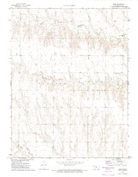
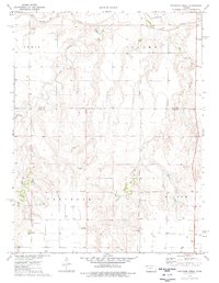
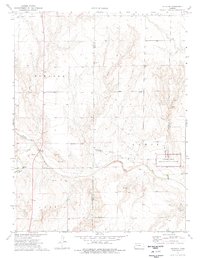
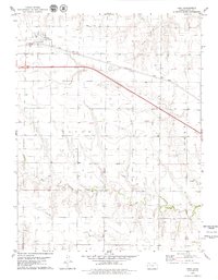
 1972 Gove NE1974 Print · USGSGove County in the early seventies remains a landscape of wide-open terrain and essential watercourses. Genealogists and researchers can trace the drainages of Hackberry Creek and E Spring Cr across the historic bounds of Payne and Baker.
 - 1972 Map of Castle Rock NW, 1974 Print
 1972 Castle Rock NW1974 Print · USGSThe Kansas high plains meet the historic westward route in the early seventies, spanning the border of Gove and Trego counties. Trace the Butterfield Overland Trail (Approx Location) past the Red Top Cem and local Well sites.
 - 1972 Map of Orion NE, 1974 Print
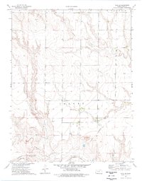
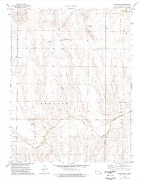
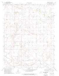
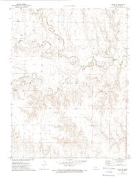 1972 Orion NE1974 Print · USGSGove County in the early 1970s displays a rural landscape shaped by the winding branches of Hackberry Creek. Researchers can trace the layout of Gove (Gove City) and locate local industrial sites like the Quarry or Gravel Pit along the prairie breaks.
 - 1972 Map of Gove, 1974 Print
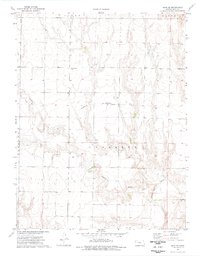
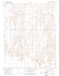
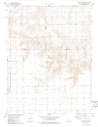
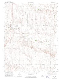 1972 Gove1974 Print · USGSThe High Plains of western Kansas are documented here in the early 1970s, centered on the community of Gove (Gove City). Genealogists and local historians can trace the rural landscape through the Gove Cem and the drainage of Hackberry Creek.
 - 1972 Map of Orion, 1974 Print
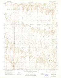
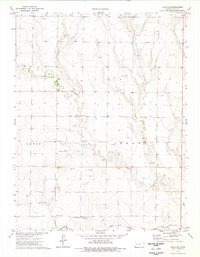
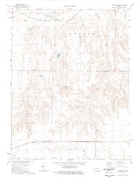
 1972 Orion1974 Print · USGSGove County in the early seventies is captured here as a landscape of remote farmsteads and dissected plains. Genealogists and researchers can trace the rural layout around Orion and the branching waterways of Middle Branch Hackberry Creek and Plum Creek.
 - 1972 Map of Elkader NE, 1974 Print
 1972 Elkader NE1974 Print · USGSWestern Kansas ranching country and the Logan-Gove county line appear here in the early 1970s. Trace the drainage of Hackberry Creek and locate local landmarks across the prairie highlands of Elkader and Gaeland O.
 - 1974 Map of Cheyenne Creek, 1976 Print
 1974 Cheyenne Creek1976 Print · USGSWestern Kansas at the mid-seventies reveals a landscape shaped by historic transit and modern extraction along the Gove and Lane County line. Trace the path of the Butterfield Overland Trail near the Smoky Hill River or locate industrial sites like the Caliche Pits.
 - 1974 Map of Gove SW, 1976 Print
 1974 Gove SW1976 Print · USGSGove County's High Plains landscape is captured here in the mid-1970s, centered on the historic Jerome township. Researchers can trace the path of the Butterfield Overland Trail and locate local landmarks like Missouri Flats Sch and the Smoky Hill River.
 - 1974 Map of Gove SE, 1976 Print
 1974 Gove SE1976 Print · USGSGove County, Kansas, is captured in the mid-seventies, showing the intersection of historic frontier routes and modern energy development. Researchers can trace the Butterfield Overland Trail and locate family landmarks like Morning Star Cem or Alanthus Cem.
 - 1974 Map of Orion SE, 1976 Print
 1974 Orion SE1976 Print · USGSGove County in the 1970s reveals a prairie landscape where pioneer history meets the modern oil industry. Researchers can find the Butterfield Overland Trail near the Smoky Hill River and trace family roots at the Swedish Lutheran Cem.
 - 1974 Map of Castle Rock, 1976 Print
 1974 Castle Rock1976 Print · USGSWestern Kansas in the mid-seventies is documented here through its high plains terrain and historical transit corridors. Researchers can trace the path of the Butterfield Overland Trail and locate landmarks like the Castle Rock formations and the Smoky Hill River.
 - 1974 Map of Healy NW, 1976 Print
 1974 Healy NW1976 Print · USGSThe Smoky Hill River valley and the western Kansas high plains are documented here in the mid-1970s. Researchers can trace the drainage networks of Hell Creek and West Salt Creek or locate local mineral resources like the Caliche Pits.
 - 1974 Map of Shields NW, 1977 Print
 1974 Shields NW1977 Print · USGSLane County and the High Plains come alive in the mid-1970s, showing a landscape defined by prairie industry and the Smoky Hill River. Researchers can locate the Shields Cem, follow the Missouri Pacific railroad line, and trace resource extraction at Caliche Pits or local Sandpits.
 - 1974 Map of Pendennis, 1977 Print
 1974 Pendennis1977 Print · USGSLane County and Gove County during the mid-seventies reveal a landscape of river valleys and active oil fields. Genealogists and historians can trace the small rail settlement of Pendennis and the White Rock Cem along the Missouri Pacific line.
 - 1974 Map of Elkader, 1977 Print
 1974 Elkader1977 Print · USGSWestern Kansas at the mid-seventies reveals a landscape shaped by the Smoky Hill River and the legacies of frontier travel. Trace the Butterfield Trail near the Chalk Pyramids and the historic settlement of Elkader.2 unique versions available
 - 1974 Map of Orion SW, 1977 Print
 1974 Orion SW1977 Print · USGSGove County, Kansas, is shown in the mid-1970s as a landscape of wide-open prairie and historic transit routes. You can trace the Butterfield Trail across the terrain or locate isolated landmarks like a solitary Grave and a Sandpit.
 - 1976 Map of Lake Scott NE, 1978 Print
 1976 Lake Scott NE1978 Print · USGSWestern Kansas at the mid-seventies reveals a landscape of high-plains agriculture and emerging energy sites. Genealogists and local historians can trace family land via field lines near Ryan, visit the Keystone Cem, and follow the seasonal flow of Hell Creek.
 - 1979 Map of Park
 1979 Park1979 Print · USGSGove County's high plains are documented in the late 1970s, showing the intersection of the modern interstate and traditional rail transport. Researchers can locate the settlement of Park, the siding at Tully, and the drainage patterns of Big Creek and Cow Draw.
Showing maps 1-25 of 39
Top cities of Gove County
Frequently asked questions
- What are the different types of historical maps available for Gove County?
- What is the oldest map of Gove County?
- Where can I purchase historical maps of Gove County for my home or office?
- Where can I download high-res historical maps of Gove County?
- Are there historical topographic maps available for Gove County?
- Is there historical aerial imagery available for Gove County?
- Where are historical maps of Gove County sourced from?