1970s Maps of Hanston, Kansas
Explore 2 historic maps of Hanston from the 1970s. These maps offer a rare glimpse into what life looked like during the 1970s — showing old roads, neighborhoods, homes, and landmarks that have changed or disappeared over time.
Whether you're researching your family's past, planning a metal detecting trip, or studying how Hanston's landscape evolved across the 1970s, these high-resolution maps are a powerful tool for exploring the history of this region.
- Focus on a specific era: All maps on this page are from the 1970s, giving you a focused view of this time period.
- See what’s changed: Compare century-old streets, trails, and buildings to today's modern landscape using overlays and satellite layers.
- Research with precision: Use these maps for genealogy, historical research, land use analysis, or educational projects.
- View, download, or print: Maps are fully viewable online in high resolution, and can be downloaded or printed for your own records.
Start exploring Hanston's history through authentic maps from the 1970s. This is your window into the past.
Hanston, KS maps
(2)- 1970 Map of Hanston, 1971 Print
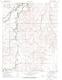 1970 Hanston1971 Print · USGSHodgeman County's agricultural and energy landscape comes into focus around 1970, centered on the community of Hanston. Researchers can trace early infrastructure and family landmarks through features like St Anthony Cem, the Orwell settlement, and several active oil fields.
 - 1970 Map of Hanston NW, 1971 Print
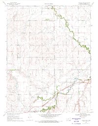 1970 Hanston NW1971 Print · USGSWestern Kansas at the start of the 1970s shows a landscape shaped by its waterways and the steel of the Atchison Topeka and Santa Fe. Genealogists and local historians can locate the Hanston Cem, the Hodgeman Community Ch, and Dungans Crossing.
End of results
Showing maps 1-2 of 2
Top cities near Hanston
Frequently asked questions
- What are the different types of historical maps available for Hanston?
- What is the oldest map of Hanston?
- Where can I purchase historical maps of Hanston for my home or office?
- Where can I download high-res historical maps of Hanston?
- Are there historical topographic maps available for Hanston?
- Is there historical aerial imagery available for Hanston?
- Where are historical maps of Hanston sourced from?