1930s Maps of Pointe At Prairie Haven, Merriam
Explore 2 historic maps of Pointe At Prairie Haven from the 1930s. These maps offer a rare glimpse into what life looked like during the 1930s — showing old roads, neighborhoods, homes, and landmarks that have changed or disappeared over time.
Whether you're researching your family's past, planning a metal detecting trip, or studying how Pointe At Prairie Haven's landscape evolved across the 1930s, these high-resolution maps are a powerful tool for exploring the history of this region.
- Focus on a specific era: All maps on this page are from the 1930s, giving you a focused view of this time period.
- See what’s changed: Compare century-old streets, trails, and buildings to today's modern landscape using overlays and satellite layers.
- Research with precision: Use these maps for genealogy, historical research, land use analysis, or educational projects.
- View, download, or print: Maps are fully viewable online in high resolution, and can be downloaded or printed for your own records.
Start exploring Pointe At Prairie Haven's history through authentic maps from the 1930s. This is your window into the past.
Pointe At Prairie Haven, Merriam maps
(2)- 1934 Map of Shawnee
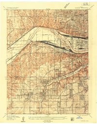 1934 Shawnee1934 Print · USGSThe Kansas River valley and the developing suburbs of Johnson County are shown in detail during the early 1930s. Researchers can trace historic neighborhoods and transit lines including Merriam, Argentine High Sch, and the Kansas and Missouri Interurban.3 unique versions available
 - 1935 Map of Lenexa
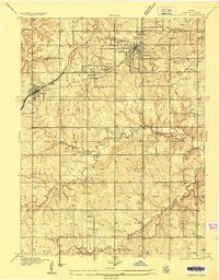 1935 Lenexa1935 Print · USGSJohnson County during the mid-thirties reveals a landscape of expanding suburbs and rural school districts connected by the St Louis and San Francisco RR. Trace early neighborhood growth around Lenexa and Overland Park, or locate landmarks like the Mission Valley Hunt Club.2 unique versions available
End of results
Showing maps 1-2 of 2
Frequently asked questions
- What are the different types of historical maps available for Pointe At Prairie Haven?
- What is the oldest map of Pointe At Prairie Haven?
- Where can I purchase historical maps of Pointe At Prairie Haven for my home or office?
- Where can I download high-res historical maps of Pointe At Prairie Haven?
- Are there historical topographic maps available for Pointe At Prairie Haven?
- Is there historical aerial imagery available for Pointe At Prairie Haven?
- Where are historical maps of Pointe At Prairie Haven sourced from?