1900s (20th Century) Maps of Victor, Kansas
Explore 4 historic maps of Victor from the 1900s (20th Century). These maps offer a rare glimpse into what life looked like during the 1900s — showing old roads, neighborhoods, homes, and landmarks that have changed or disappeared over time.
Whether you're researching your family's past, planning a metal detecting trip, or studying how Victor's landscape evolved across the 1900s, these high-resolution maps are a powerful tool for exploring the history of this region.
- Focus on a specific era: All maps on this page are from the 1900s, giving you a focused view of this time period.
- See what’s changed: Compare century-old streets, trails, and buildings to today's modern landscape using overlays and satellite layers.
- Research with precision: Use these maps for genealogy, historical research, land use analysis, or educational projects.
- View, download, or print: Maps are fully viewable online in high resolution, and can be downloaded or printed for your own records.
Start exploring Victor's history through authentic maps from the 1900s. This is your window into the past.
Victor, KS maps
(4)- 1955 Map of Beloit, 1971 Print
 1955 Beloit1971 Print · USGSNorth Central Kansas in the mid-fifties shows a landscape of river-valley agriculture and expanding water infrastructure. Genealogists can trace the rail lines of the Union Pacific through towns like Nicodemus, Cawker City, and the State Sanatorium.3 unique versions available
 - 1959 Map of Beloit
 1959 Beloit1959 Print · USGSNorth Central Kansas at mid-century reveals a landscape shaped by river valleys and the expansion of massive water reservoirs. Genealogists and historians can trace the rail-town connections of Beloit and Norton or locate the site of the new Webster Dam.3 unique versions available
 - 1968 Map of Ash Grove, 1969 Print
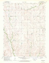 1968 Ash Grove1969 Print · USGSNorth-central Kansas ranching and rail lands are captured here in the late sixties as the local economy centered on the creek-side townships. Genealogists and historians can trace family locations near Bethany Ch, Patterson Cem, and the rail stop at Ash Grove.
 - 1985 Map of Beloit
 1985 Beloit1985 Print · USGSNorth Central Kansas in the mid-eighties shows a landscape shaped by the Solomon and Saline rivers and the massive Waconda Lake. Researchers can trace the routes of the Missouri Pacific RR and locate rural landmarks like the State Girls School and Denmark.2 unique versions available
End of results
Showing maps 1-4 of 4
Top cities near Victor
- Beloit historical maps
- Tipton historical maps
- Vesper historical maps
- Grant historical maps
- Hunter historical maps
- Blue Hill historical maps
Frequently asked questions
- What are the different types of historical maps available for Victor?
- What is the oldest map of Victor?
- Where can I purchase historical maps of Victor for my home or office?
- Where can I download high-res historical maps of Victor?
- Are there historical topographic maps available for Victor?
- Is there historical aerial imagery available for Victor?
- Where are historical maps of Victor sourced from?