1960s Maps of Centralia, Kansas
Explore 2 historic maps of Centralia from the 1960s. These maps offer a rare glimpse into what life looked like during the 1960s — showing old roads, neighborhoods, homes, and landmarks that have changed or disappeared over time.
Whether you're researching your family's past, planning a metal detecting trip, or studying how Centralia's landscape evolved across the 1960s, these high-resolution maps are a powerful tool for exploring the history of this region.
- Focus on a specific era: All maps on this page are from the 1960s, giving you a focused view of this time period.
- See what’s changed: Compare century-old streets, trails, and buildings to today's modern landscape using overlays and satellite layers.
- Research with precision: Use these maps for genealogy, historical research, land use analysis, or educational projects.
- View, download, or print: Maps are fully viewable online in high resolution, and can be downloaded or printed for your own records.
Start exploring Centralia's history through authentic maps from the 1960s. This is your window into the past.
Centralia, KS maps
(2)- 1969 Map of Centralia, 1971 Print
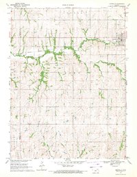 1969 Centralia1971 Print · USGSCentralia sits at a rail-and-river crossroads in the late sixties, where the Missouri Pacific line meets the winding Black Vermillion River. Researchers can trace the layout of the town and its outlying rural townships, including locations like Centralia Cem and Mulberry Cem.
 - 1969 Map of Corning, 1971 Print
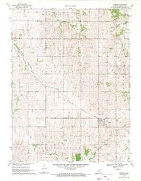 1969 Corning1971 Print · USGSSouthern Nemaha County comes into focus in the late 1960s, showing the agricultural heartland of Kansas and its vital railroad corridors. Researchers can trace historic family burial sites at St Patrick Cem and Roots Cem or follow the Missouri Pacific line through Corning.
End of results
Showing maps 1-2 of 2
Top cities near Centralia
- Seneca historical maps
- Axtell historical maps
- Goff historical maps
- Corning historical maps
- Havensville historical maps
- Soldier historical maps
See more
Frequently asked questions
- What are the different types of historical maps available for Centralia?
- What is the oldest map of Centralia?
- Where can I purchase historical maps of Centralia for my home or office?
- Where can I download high-res historical maps of Centralia?
- Are there historical topographic maps available for Centralia?
- Is there historical aerial imagery available for Centralia?
- Where are historical maps of Centralia sourced from?