1800s (19th Century) Maps of Neosho County, Kansas
Explore 8 historic maps of Neosho County from the 1800s (19th Century). These maps offer a rare glimpse into what life looked like during the 1800s — showing old roads, neighborhoods, homes, and landmarks that have changed or disappeared over time.
Whether you're researching your family's past, planning a metal detecting trip, or studying how Neosho County's landscape evolved across the 1800s, these high-resolution maps are a powerful tool for exploring the history of this region.
- Focus on a specific era: All maps on this page are from the 1800s, giving you a focused view of this time period.
- See what’s changed: Compare century-old streets, trails, and buildings to today's modern landscape using overlays and satellite layers.
- Research with precision: Use these maps for genealogy, historical research, land use analysis, or educational projects.
- View, download, or print: Maps are fully viewable online in high resolution, and can be downloaded or printed for your own records.
Start exploring Neosho County's history through authentic maps from the 1800s. This is your window into the past.
Neosho County, KS maps
(8)- 1886 Map of Fredonia
 1886 Fredonia1886 Print · USGSSoutheast Kansas in the mid-1880s was a land of emerging rail hubs and river valley settlements. Researchers can trace early railroad expansion through Fredonia and Yates Center or locate long-standing communities like Toronto, New Albany, and Coyville.
 - 1886 Map of Iola
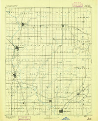
 1886 Iola1886 Print · USGSEastern Kansas was a bustling corridor of competing rail lines and river settlements during the mid-1880s. Genealogists and historians can trace the early footprints of Osage Mission, the growth of Iola, and vanished stops like Warnersburgh along the winding Neosho River.
 - 1886 Map of Independence
 1886 Independence1886 Print · USGSSoutheastern Kansas is captured here in the mid-1880s as the railroad network began to reshape the prairie landscape. Genealogists and researchers can trace the early foundations of Independence, Cherryvale, and Coffeyville, or locate smaller places like Radical City and La Fontaine.
 - 1886 Map of Parsons
 1886 Parsons1886 Print · USGSSoutheast Kansas at the height of the railroad boom is anchored here by the growing hub of Parsons. Genealogists and historians can trace the early townships and rail sidings that shaped Labette County, from Oswego and Chetopa to rural stops like Ladore and Altamont.
 - 1893 Map of Iola
 1893 Iola1893 Print · USGSSoutheast Kansas at the end of the nineteenth century is captured here as a thriving rail and river corridor. Genealogists and historians can trace the early development of Iola, Erie, and Humboldt or locate smaller settlements like Odense and Veitsburgh.2 unique versions available
 - 1893 Map of Parsons
 1893 Parsons1893 Print · USGSSoutheastern Kansas was a booming rail center in the late nineteenth century, dominated by the rise of Parsons. Genealogists can trace family connections through early settlements like Ladore, Mound Valley, and Altamont or along the Little Labette Creek drainage.4 unique versions available
 - 1894 Map of Fredonia
 1894 Fredonia1894 Print · USGSSoutheast Kansas is documented here during a period of rapid railway expansion and prairie settlement. Genealogists and local researchers can trace the early footprints of Fredonia, Yates Center, and vanished sites like Twin Mounds or Coyville.6 unique versions available
 - 1894 Map of Independence
 1894 Independence1894 Print · USGSSoutheast Kansas comes alive in the late nineteenth century as a major railroad junction before the turn of the century. Genealogists and historians can trace early settlements like Radical City, Sternerton, and Harrisonville, or locate family sites near Table Mound.
End of results
Showing maps 1-8 of 8
Top cities of Neosho County
- Chanute historical maps
- Erie historical maps
- Thayer historical maps
- Galesburg historical maps
- Stark historical maps
- Earlton historical maps
Frequently asked questions
- What are the different types of historical maps available for Neosho County?
- What is the oldest map of Neosho County?
- Where can I purchase historical maps of Neosho County for my home or office?
- Where can I download high-res historical maps of Neosho County?
- Are there historical topographic maps available for Neosho County?
- Is there historical aerial imagery available for Neosho County?
- Where are historical maps of Neosho County sourced from?