1960s Maps of Wheaton, Kansas
Explore 2 historic maps of Wheaton from the 1960s. These maps offer a rare glimpse into what life looked like during the 1960s — showing old roads, neighborhoods, homes, and landmarks that have changed or disappeared over time.
Whether you're researching your family's past, planning a metal detecting trip, or studying how Wheaton's landscape evolved across the 1960s, these high-resolution maps are a powerful tool for exploring the history of this region.
- Focus on a specific era: All maps on this page are from the 1960s, giving you a focused view of this time period.
- See what’s changed: Compare century-old streets, trails, and buildings to today's modern landscape using overlays and satellite layers.
- Research with precision: Use these maps for genealogy, historical research, land use analysis, or educational projects.
- View, download, or print: Maps are fully viewable online in high resolution, and can be downloaded or printed for your own records.
Start exploring Wheaton's history through authentic maps from the 1960s. This is your window into the past.
Wheaton, KS maps
(2)- 1964 Map of Westmoreland NE, 1965 Print
 1964 Westmoreland NE1965 Print · USGSPottawatomie County during the mid-sixties remains a deeply rural landscape of townships and creek valleys. Genealogists and local historians can trace the paths to St Michaels Cem, Fairview Cem, and the Old Indian Treaty Bdy.2 unique versions available
 - 1969 Map of Wheaton, 1971 Print
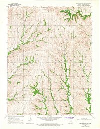
 1969 Wheaton1971 Print · USGSPottawatomie County in the late sixties reveals a landscape of enduring family farms and evolving rail lines. Genealogists and local historians can trace the paths between Wheaton, Lillis, and St Josephs Ch or locate rural burials at Clear Creek Cem.2 unique versions available
End of results
Showing maps 1-2 of 2
Top cities near Wheaton
- Frankfort historical maps
- Westmoreland historical maps
- Onaga historical maps
- Centralia historical maps
- Neuchatel historical maps
- Vermillion historical maps
Frequently asked questions
- What are the different types of historical maps available for Wheaton?
- What is the oldest map of Wheaton?
- Where can I purchase historical maps of Wheaton for my home or office?
- Where can I download high-res historical maps of Wheaton?
- Are there historical topographic maps available for Wheaton?
- Is there historical aerial imagery available for Wheaton?
- Where are historical maps of Wheaton sourced from?