1900s (20th Century) Maps of Palco, Kansas
Explore 5 historic maps of Palco from the 1900s (20th Century). These maps offer a rare glimpse into what life looked like during the 1900s — showing old roads, neighborhoods, homes, and landmarks that have changed or disappeared over time.
Whether you're researching your family's past, planning a metal detecting trip, or studying how Palco's landscape evolved across the 1900s, these high-resolution maps are a powerful tool for exploring the history of this region.
- Focus on a specific era: All maps on this page are from the 1900s, giving you a focused view of this time period.
- See what’s changed: Compare century-old streets, trails, and buildings to today's modern landscape using overlays and satellite layers.
- Research with precision: Use these maps for genealogy, historical research, land use analysis, or educational projects.
- View, download, or print: Maps are fully viewable online in high resolution, and can be downloaded or printed for your own records.
Start exploring Palco's history through authentic maps from the 1900s. This is your window into the past.
Palco, KS maps
(5)- 1955 Map of Beloit, 1971 Print
 1955 Beloit1971 Print · USGSNorth Central Kansas in the mid-fifties shows a landscape of river-valley agriculture and expanding water infrastructure. Genealogists can trace the rail lines of the Union Pacific through towns like Nicodemus, Cawker City, and the State Sanatorium.3 unique versions available
 - 1959 Map of Beloit
 1959 Beloit1959 Print · USGSNorth Central Kansas at mid-century reveals a landscape shaped by river valleys and the expansion of massive water reservoirs. Genealogists and historians can trace the rail-town connections of Beloit and Norton or locate the site of the new Webster Dam.3 unique versions available
 - 1969 Map of Palco, 1971 Print
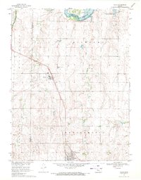 1969 Palco1971 Print · USGSRooks County agricultural and oil-producing lands are captured here in the late sixties, centered on the Union Pacific rail line. Genealogists and local historians can locate St Joseph Cem and Palco Cem, or trace the development of the Gra-Rook North Oil Field.
 - 1979 Map of Wild Horse Creek
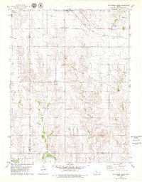 1979 Wild Horse Creek1979 Print · USGSIn the late 1970s, this Rooks County landscape was a hub of energy production and rail transport. Genealogists and historians can trace the community structures of Palco and find landmarks like Pleasantview Cem and the Marcotte Oil Field.2 unique versions available
 - 1985 Map of Plainville
 1985 Plainville1985 Print · USGSNorthwestern Kansas in the mid-eighties reveals a landscape shaped by the Solomon River and the expansion of energy production. Researchers can trace the Union Pacific rail line and locate key sites like the historic settlement of Nicodemus, Webster Reservoir, and numerous oil fields.2 unique versions available
End of results
Showing maps 1-5 of 5
Top cities near Palco
Frequently asked questions
- What are the different types of historical maps available for Palco?
- What is the oldest map of Palco?
- Where can I purchase historical maps of Palco for my home or office?
- Where can I download high-res historical maps of Palco?
- Are there historical topographic maps available for Palco?
- Is there historical aerial imagery available for Palco?
- Where are historical maps of Palco sourced from?