Old Maps of Smith County, Kansas
Explore 160 old maps of Smith County, spanning from 1893 to today. These high-resolution historic maps reveal how streets, neighborhoods, landmarks, and natural features evolved over time — perfect for genealogy, metal detecting, research, and local history exploration.
What you can do with these maps:
- See how Smith County changed over time: Compare historical maps to modern-day views to trace roads, homesites, rail lines & more.
- View detailed metadata: Each map includes creators, publishers, year, scale, and archive source.
- Overlay maps with satellite & LiDAR: Visualize the past alongside modern tools to explore terrain & human change.
- Trusted historical sources: Maps sourced from the USGS, Library of Congress, and other archives.
- Access maps your way: View online, download high-res files, or order prints for personal or research use.
Start exploring old maps of Smith County to uncover forgotten places, hidden landmarks, and the deep history beneath your feet.
Smith County, KS maps
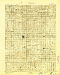
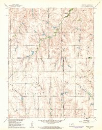
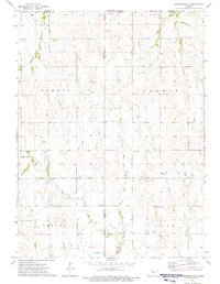
(160)- 1893 Map of Smith Center
 1893 Smith Center1893 Print · USGSNorth-central Kansas emerges in the early 1890s as a landscape of grid-patterned townships and growing rail towns. Researchers can trace the early footprints of Smith Center and Lebanon or locate vanished points like Jacksonburg and Womer.3 unique versions available
 - 1893 Map of Phillipsburg
 1893 Phillipsburg1893 Print · USGSPhillips County was a burgeoning rail and river corridor in the 1890s, with three major railroads carving paths through the prairie townships. Genealogists and researchers can trace the early layouts of Phillipsburg, Kirwin, and Agra as they appeared before the turn of the century.4 unique versions available
 - 1896 Map of Holdrege
 1896 Holdrege1896 Print · USGSSouth-central Nebraska was a burgeoning network of rail towns and river settlements in the late nineteenth century. Genealogists can trace family roots along the Republican River valley in Alma, Bloomington, and Naponee, or explore the early growth of Holdrege as a vital railroad junction.5 unique versions available
 - 1897 Map of Red Cloud
 1897 Red Cloud1897 Print · USGSSouthern Nebraska and the Kansas borderlands were being transformed by heavy rail expansion in the 1890s. Genealogists can trace family farmsteads near Red Cloud and Minden, or follow the Republican River to see the early layouts of Riverton and Franklin.4 unique versions available
 - 1940 Map of Red Cloud, 1954 Print
 1940 Red Cloud1954 Print · USGSSouthern Nebraska at the end of the Great Depression is characterized by its close-knit rural school districts and river-valley rail lines. Genealogists can trace family roots through numerous landmarks like Catherton Cem, St Stevens Ch, and the Poor Farm Sch.2 unique versions available
 - 1942 Map of Red Cloud
 1942 Red Cloud1942 Print · USGSRed Cloud and the surrounding Republican River valley are shown here just before the mid-century, when the rural school system remained remarkably intact. Researchers can trace family roots through numerous sites like New Virginia Cem, Poor Farm Sch, and Inavale.
 - 1955 Map of Grand Island, 1967 Print
 1955 Grand Island1967 Print · USGSCentral Nebraska is seen here during a period of industrial and agricultural growth, centered on the vital Platte River corridor. Researchers can trace the mid-century footprints of the U S Naval Ammunition Depot and the Cornhusker Ordnance Plant.3 unique versions available
 - 1955 Map of Beloit, 1971 Print
 1955 Beloit1971 Print · USGSNorth Central Kansas in the mid-fifties shows a landscape of river-valley agriculture and expanding water infrastructure. Genealogists can trace the rail lines of the Union Pacific through towns like Nicodemus, Cawker City, and the State Sanatorium.3 unique versions available
 - 1957 Map of Grand Island
 1957 Grand Island1957 Print · USGSCentral Nebraska and Northern Kansas are shown here during a period of massive hydraulic and military expansion in the mid-fifties. Researchers can trace the development of the Harlan County Reservoir and the massive wartime legacy of the Cornhusker Ordnance Plant.
 - 1958 Map of Grand Island
 1958 Grand Island1958 Print · USGSSouth-central Nebraska thrived as a rail and industrial hub during the late fifties, shaped by the braided Platte River. Genealogists and historians can trace rail lines like the Union Pacific RR through towns such as Kearney or locate the sprawling Cornhusker Ordnance Plant.
 - 1959 Map of Beloit
 1959 Beloit1959 Print · USGSNorth Central Kansas at mid-century reveals a landscape shaped by river valleys and the expansion of massive water reservoirs. Genealogists and historians can trace the rail-town connections of Beloit and Norton or locate the site of the new Webster Dam.3 unique versions available
 - 1960 Map of Downs North, 1962 Print
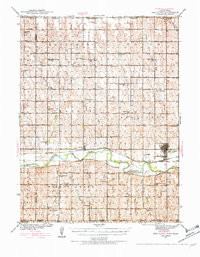
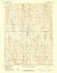
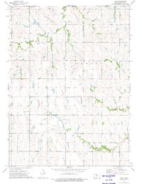
 1960 Downs North1962 Print · USGSThe Smith and Osborne County borderlands come to life in the early 1960s at the junction of the Solomon River forks. Researchers can locate vanished rural landmarks like Pleasant Ridge Sch, the settlement of Dispatch, and Rose Valley Ch.2 unique versions available
 - 1961 Map of Kirwin SE, 1962 Print
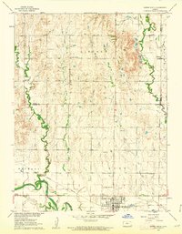
 1961 Kirwin SE1962 Print · USGSThe rural crossroads of Rooks, Phillips, Smith, and Osborne counties are captured here in the early sixties. Genealogists can locate family sites and rural landmarks like Bohemian Cem, Spring Branch Cem, and Ash Rock Sch 2.
 - 1961 Map of Portis, 1962 Print
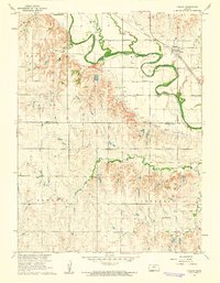
 1961 Portis1962 Print · USGSThe Osborne County plains in the early sixties reveal a landscape of river-valley farming and rail transport. Genealogists can trace family landmarks like Fairview Cem and Garrett Cem near the North Fork Solomon River.
 - 1961 Map of Harlan, 1962 Print
 1961 Harlan1962 Print · USGSNorth central Kansas farmland is documented here in the early 1960s, showing the intricate water management along the North Fork Solomon River. Genealogists and local historians can locate the Harlan townsite, Butler Cem, and rural congregations like Mayflower Ch.
 - 1961 Map of Gaylord SW, 1962 Print
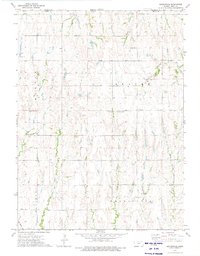
 1961 Gaylord SW1962 Print · USGSNorth-central Kansas in the early 1960s was a landscape of township divisions and rural stream valleys. Genealogists and local historians can trace family locations near Leasburg Cem, Grant Cem, and the waters of Glen Creek.
 - 1972 Map of Kirwin, 1974 Print
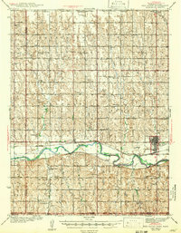
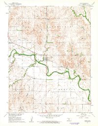
 1972 Kirwin1974 Print · USGSThe North Fork Solomon River valley in the early 1970s shows a landscape transformed by the Kirwin Dam. Researchers can trace the Missouri Pacific rail line through Kirwin and Claudell or locate the Olive Branch Cem near the reservoir.
 - 1973 Map of Kensington, 1975 Print
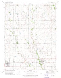 1973 Kensington1975 Print · USGSNorth-central Kansas farmland comes into focus in the early 1970s as the rail line connects small prairie towns. Genealogists can trace family footprints near Johnson Ch, the Germantown Cem, and the rail stops at Agra and Kensington.
 - 1973 Map of Athol, 1975 Print
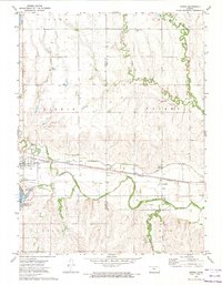
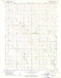
 1973 Athol1975 Print · USGSSmith County, Kansas, was a landscape of structured prairie and small-town rail service in the early 1970s. Trace family roots at Meade Cem or Pleasant View Cem, and follow the Chicago Rock Island and Pacific tracks through Athol.
 - 1973 Map of Portis NE, 1975 Print
 1973 Portis NE1975 Print · USGSSmith County, Kansas, in the early seventies shows a landscape of upland plateaus and intricate creek valleys before modern consolidation. Genealogists and local historians can locate the Townhall, Oak Creek Ch, and family burial sites like North Oak Creek Cem.
 - 1973 Map of Kensington NE, 1975 Print
 1973 Kensington NE1975 Print · USGSThe rural borderlands of Phillips and Smith counties are captured in the early 1970s, showing a traditional Kansas farm landscape. Researchers can locate remote landmarks like Pleasant Green Ch, Stone Cem, and the various branches of Cedar Creek.
 - 1973 Map of Cora, 1975 Print
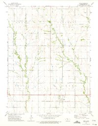
 1973 Cora1975 Print · USGSSmith County agriculture and township life are captured here in the early seventies as small communities remained the hub of rural Kansas. Genealogists and local historians can trace landmarks like the Cedar Hill Cem, the Townhall, and the settlement of Womer.
 - 1973 Map of Reamsville, 1975 Print
 1973 Reamsville1975 Print · USGSSmith County, Kansas, is shown here in the 1970s just south of the Nebraska state line. Genealogists and local historians can trace the rural communities of Reamsville and Thornburg, or locate burial sites at Pleasant Hill Cem and Eminence Cem.
 - 1973 Map of Cedar, 1975 Print
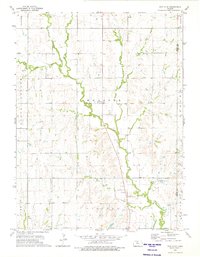
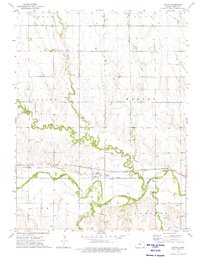 1973 Cedar1975 Print · USGSCedar and the Solomon River valley are captured here in the early 1970s during a period of established rail and irrigation infrastructure. Researchers can trace the layout of the Cedar townsite and locate community anchors like St Francis Cem and the Missouri Pacific line.
 - 1973 Map of Bachelors Run, 1975 Print
 1973 Bachelors Run1975 Print · USGSThe rural border of Smith and Franklin Counties is documented here in the early 1970s, showing a landscape of rolling drainages and section-line farms. Local researchers can locate Pleasant Hill Cem and trace the paths of Bachelors Run and Middle Beaver Creek.
Showing maps 1-25 of 160
Top cities of Smith County
- Smith Center historical maps
- Kensington historical maps
- Lebanon historical maps
- Gaylord historical maps
- Harlan historical maps
- Athol historical maps
See more
Frequently asked questions
- What are the different types of historical maps available for Smith County?
- What is the oldest map of Smith County?
- Where can I purchase historical maps of Smith County for my home or office?
- Where can I download high-res historical maps of Smith County?
- Are there historical topographic maps available for Smith County?
- Is there historical aerial imagery available for Smith County?
- Where are historical maps of Smith County sourced from?