1960s Maps of Stafford County, Kansas
Explore 3 historic maps of Stafford County from the 1960s. These maps offer a rare glimpse into what life looked like during the 1960s — showing old roads, neighborhoods, homes, and landmarks that have changed or disappeared over time.
Whether you're researching your family's past, planning a metal detecting trip, or studying how Stafford County's landscape evolved across the 1960s, these high-resolution maps are a powerful tool for exploring the history of this region.
- Focus on a specific era: All maps on this page are from the 1960s, giving you a focused view of this time period.
- See what’s changed: Compare century-old streets, trails, and buildings to today's modern landscape using overlays and satellite layers.
- Research with precision: Use these maps for genealogy, historical research, land use analysis, or educational projects.
- View, download, or print: Maps are fully viewable online in high resolution, and can be downloaded or printed for your own records.
Start exploring Stafford County's history through authentic maps from the 1960s. This is your window into the past.
Stafford County, KS maps
(3)- 1960 Map of Pawnee Rock, 1961 Print
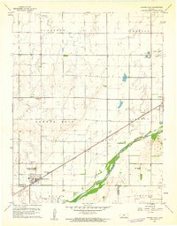 1960 Pawnee Rock1961 Print · USGSThe Kansas river valley near Pawnee Rock was a landscape of rail-driven transit and early oil exploration in the 1960s. Genealogists and historians can locate rural landmarks like Bergtal Ch, the namesake Pawnee Rock State Park, and the tracks of the Atchison Topeka and Santa Fe.2 unique versions available
 - 1967 Map of Alden NW, 1968 Print
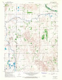 1967 Alden NW1968 Print · USGSCentral Kansas wetlands and energy development meet in the late sixties at the border of Rice, Stafford, and Reno counties. Local historians can trace the early boundaries of Quivira National Wildlife Refuge and locate old Oil Wells near Dead Horse Slough.
 - 1969 Map of Radium, 1971 Print
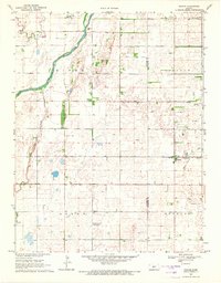 1969 Radium1971 Print · USGSStafford and Pawnee counties during the late sixties show a prairie landscape shaped by the Missouri Pacific railroad and early oil exploration. Genealogists can locate family sites near Pleasant Ridge Cem or trace the development of the Radium Townsite.
End of results
Showing maps 1-3 of 3
Top cities of Stafford County
- St. John historical maps
- Stafford historical maps
- Macksville historical maps
- Hudson historical maps
- Seward historical maps
- Radium historical maps
Frequently asked questions
- What are the different types of historical maps available for Stafford County?
- What is the oldest map of Stafford County?
- Where can I purchase historical maps of Stafford County for my home or office?
- Where can I download high-res historical maps of Stafford County?
- Are there historical topographic maps available for Stafford County?
- Is there historical aerial imagery available for Stafford County?
- Where are historical maps of Stafford County sourced from?