1890s Maps of Stanton County, Kansas
Explore 3 historic maps of Stanton County from the 1890s. These maps offer a rare glimpse into what life looked like during the 1890s — showing old roads, neighborhoods, homes, and landmarks that have changed or disappeared over time.
Whether you're researching your family's past, planning a metal detecting trip, or studying how Stanton County's landscape evolved across the 1890s, these high-resolution maps are a powerful tool for exploring the history of this region.
- Focus on a specific era: All maps on this page are from the 1890s, giving you a focused view of this time period.
- See what’s changed: Compare century-old streets, trails, and buildings to today's modern landscape using overlays and satellite layers.
- Research with precision: Use these maps for genealogy, historical research, land use analysis, or educational projects.
- View, download, or print: Maps are fully viewable online in high resolution, and can be downloaded or printed for your own records.
Start exploring Stanton County's history through authentic maps from the 1890s. This is your window into the past.
Stanton County, KS maps
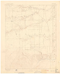
(3)- 1891 Map of Albany
 1891 Albany1891 Print · USGSThe Colorado-Kansas borderlands were a crossroads of historic transit in the early 1890s. Genealogists and historians can trace the paths of the Santa Fe Trail and Texas Trail past frontier outposts like Albany and Kline Ranche.
 - 1892 Map of Vilas
 1892 Vilas1892 Print · USGSSoutheast Colorado and the Kansas borderland are shown here in the early 1890s, when ranching and the cattle trade dominated the high plains. Genealogists and historians can trace the Texas Trail and early settlements like Boston, Vilas, and Mathews Ranch.5 unique versions available
 - 1893 Map of Albany
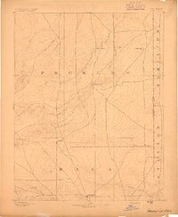 1893 Albany1893 Print · USGSThe high plains of the Colorado-Kansas border are documented here in the early 1890s, when overland travel routes still shaped the land. Local historians can trace the paths of the Santa Fe Trail and Texas Trail past early settlements like Albany and Kline Ranche.5 unique versions available
End of results
Showing maps 1-3 of 3
Top cities of Stanton County
Frequently asked questions
- What are the different types of historical maps available for Stanton County?
- What is the oldest map of Stanton County?
- Where can I purchase historical maps of Stanton County for my home or office?
- Where can I download high-res historical maps of Stanton County?
- Are there historical topographic maps available for Stanton County?
- Is there historical aerial imagery available for Stanton County?
- Where are historical maps of Stanton County sourced from?