1960s Maps of Hunnewell, Kansas
Explore 2 historic maps of Hunnewell from the 1960s. These maps offer a rare glimpse into what life looked like during the 1960s — showing old roads, neighborhoods, homes, and landmarks that have changed or disappeared over time.
Whether you're researching your family's past, planning a metal detecting trip, or studying how Hunnewell's landscape evolved across the 1960s, these high-resolution maps are a powerful tool for exploring the history of this region.
- Focus on a specific era: All maps on this page are from the 1960s, giving you a focused view of this time period.
- See what’s changed: Compare century-old streets, trails, and buildings to today's modern landscape using overlays and satellite layers.
- Research with precision: Use these maps for genealogy, historical research, land use analysis, or educational projects.
- View, download, or print: Maps are fully viewable online in high resolution, and can be downloaded or printed for your own records.
Start exploring Hunnewell's history through authentic maps from the 1960s. This is your window into the past.
Hunnewell, KS maps
(2)- 1965 Map of South Haven, 1966 Print
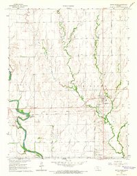 1965 South Haven1966 Print · USGSThe Kansas-Oklahoma borderlands in the mid-1960s reveal a landscape of rail-dependent towns and historic territorial lines. Trace the Old Indian Treaty Boundary as it passes between the settlements of South Haven and Hunnewell.
 - 1968 Map of Blackwell NW, 1970 Print
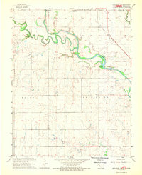 1968 Blackwell NW1970 Print · USGSThe Oklahoma-Kansas borderlands are captured here in the late sixties, where the Chikaskia River winds through the northern prairie. Researchers can trace rural genealogy and industry through sites like Triumph Cem, the Asbury Ch, and the extensive Webb North Oil Field.2 unique versions available
End of results
Showing maps 1-2 of 2
Top cities near Hunnewell
- Wellington historical maps
- Blackwell historical maps
- Caldwell historical maps
- South Haven historical maps
- Braman historical maps
- Deer Creek historical maps
Frequently asked questions
- What are the different types of historical maps available for Hunnewell?
- What is the oldest map of Hunnewell?
- Where can I purchase historical maps of Hunnewell for my home or office?
- Where can I download high-res historical maps of Hunnewell?
- Are there historical topographic maps available for Hunnewell?
- Is there historical aerial imagery available for Hunnewell?
- Where are historical maps of Hunnewell sourced from?