1970s Maps of Wellington, Kansas
Explore 2 historic maps of Wellington from the 1970s. These maps offer a rare glimpse into what life looked like during the 1970s — showing old roads, neighborhoods, homes, and landmarks that have changed or disappeared over time.
Whether you're researching your family's past, planning a metal detecting trip, or studying how Wellington's landscape evolved across the 1970s, these high-resolution maps are a powerful tool for exploring the history of this region.
- Focus on a specific era: All maps on this page are from the 1970s, giving you a focused view of this time period.
- See what’s changed: Compare century-old streets, trails, and buildings to today's modern landscape using overlays and satellite layers.
- Research with precision: Use these maps for genealogy, historical research, land use analysis, or educational projects.
- View, download, or print: Maps are fully viewable online in high resolution, and can be downloaded or printed for your own records.
Start exploring Wellington's history through authentic maps from the 1970s. This is your window into the past.
Wellington, KS maps
(2)- 1971 Map of Perth, 1973 Print
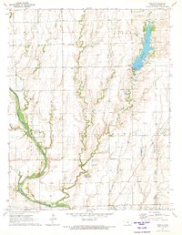 1971 Perth1973 Print · USGSSumner County during the early seventies reveals a landscape where the Chicago Rock Island and Pacific rail line still connects prairie towns like Perth and Corbin. Researchers can locate several burial grounds including United Cem and Bethany Cem or trace the drainage of the Chikaskia River.
 - 1971 Map of Mayfield, 1973 Print
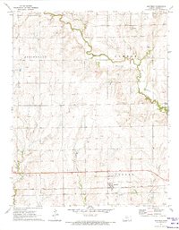 1971 Mayfield1973 Print · USGSSumner County in the early seventies shows a landscape of rail-connected farming towns and meandering prairie streams. Genealogists can locate family sites near Mayfield or Anson, and trace local burials at Austin Cem or Township Cem.
End of results
Showing maps 1-2 of 2
Top cities near Wellington
- Wichita historical maps
- Mulvane historical maps
- Clearwater historical maps
- Belle Plaine historical maps
- Conway Springs historical maps
- Caldwell historical maps
See more
Frequently asked questions
- What are the different types of historical maps available for Wellington?
- What is the oldest map of Wellington?
- Where can I purchase historical maps of Wellington for my home or office?
- Where can I download high-res historical maps of Wellington?
- Are there historical topographic maps available for Wellington?
- Is there historical aerial imagery available for Wellington?
- Where are historical maps of Wellington sourced from?