1900s (20th Century) Maps of WaKeeney, Kansas
Explore 5 historic maps of WaKeeney from the 1900s (20th Century). These maps offer a rare glimpse into what life looked like during the 1900s — showing old roads, neighborhoods, homes, and landmarks that have changed or disappeared over time.
Whether you're researching your family's past, planning a metal detecting trip, or studying how WaKeeney's landscape evolved across the 1900s, these high-resolution maps are a powerful tool for exploring the history of this region.
- Focus on a specific era: All maps on this page are from the 1900s, giving you a focused view of this time period.
- See what’s changed: Compare century-old streets, trails, and buildings to today's modern landscape using overlays and satellite layers.
- Research with precision: Use these maps for genealogy, historical research, land use analysis, or educational projects.
- View, download, or print: Maps are fully viewable online in high resolution, and can be downloaded or printed for your own records.
Start exploring WaKeeney's history through authentic maps from the 1900s. This is your window into the past.
WaKeeney, KS maps
(5)- 1955 Map of Beloit, 1971 Print
 1955 Beloit1971 Print · USGSNorth Central Kansas in the mid-fifties shows a landscape of river-valley agriculture and expanding water infrastructure. Genealogists can trace the rail lines of the Union Pacific through towns like Nicodemus, Cawker City, and the State Sanatorium.3 unique versions available
 - 1959 Map of Beloit
 1959 Beloit1959 Print · USGSNorth Central Kansas at mid-century reveals a landscape shaped by river valleys and the expansion of massive water reservoirs. Genealogists and historians can trace the rail-town connections of Beloit and Norton or locate the site of the new Webster Dam.3 unique versions available
 - 1962 Map of Wa Keeney East, 1964 Print
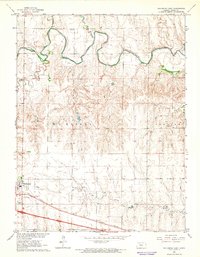 1962 Wa Keeney East1964 Print · USGSThe High Plains of Trego County come into focus in the early sixties as the regional hub of Wakeeney expands along the Union Pacific line. Researchers can locate the WaKeeney Cem, trace the winding Saline River, and find mid-century landmarks like the Drive-in Theater.
 - 1963 Map of Wa Keeney West, 1964 Print
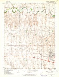 1963 Wa Keeney West1964 Print · USGSWestern Kansas at the start of the sixties reveals a transition from river-bottom ranching to a rail-and-oil economy. Trace the route of the Union Pacific through WaKeeney or locate rural landmarks like the Saline Valley Cem and Pleasant Valley Community Hall.
 - 1985 Map of Plainville
 1985 Plainville1985 Print · USGSNorthwestern Kansas in the mid-eighties reveals a landscape shaped by the Solomon River and the expansion of energy production. Researchers can trace the Union Pacific rail line and locate key sites like the historic settlement of Nicodemus, Webster Reservoir, and numerous oil fields.2 unique versions available
End of results
Showing maps 1-5 of 5
Top cities near WaKeeney
Frequently asked questions
- What are the different types of historical maps available for WaKeeney?
- What is the oldest map of WaKeeney?
- Where can I purchase historical maps of WaKeeney for my home or office?
- Where can I download high-res historical maps of WaKeeney?
- Are there historical topographic maps available for WaKeeney?
- Is there historical aerial imagery available for WaKeeney?
- Where are historical maps of WaKeeney sourced from?