1940s Maps of Leoti Township, Kansas
Explore 2 historic maps of Leoti Township from the 1940s. These maps offer a rare glimpse into what life looked like during the 1940s — showing old roads, neighborhoods, homes, and landmarks that have changed or disappeared over time.
Whether you're researching your family's past, planning a metal detecting trip, or studying how Leoti Township's landscape evolved across the 1940s, these high-resolution maps are a powerful tool for exploring the history of this region.
- Focus on a specific era: All maps on this page are from the 1940s, giving you a focused view of this time period.
- See what’s changed: Compare century-old streets, trails, and buildings to today's modern landscape using overlays and satellite layers.
- Research with precision: Use these maps for genealogy, historical research, land use analysis, or educational projects.
- View, download, or print: Maps are fully viewable online in high resolution, and can be downloaded or printed for your own records.
Start exploring Leoti Township's history through authentic maps from the 1940s. This is your window into the past.
Leoti Township, KS maps
(2)- 1941 Map of Modoc
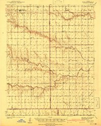 1941 Modoc1941 Print · USGSWichita and Scott counties are shown just before the war, when the rural school system and the Missouri Pacific railroad anchored the High Plains economy. Researchers can locate numerous local landmarks including St Marys Cem, Lydia Ch, and schools like Prairie Bell Sch.
 - 1941 Map of Pence
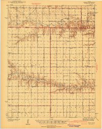 1941 Pence1941 Print · USGSWestern Kansas high plains life is preserved here during the late Depression era, showing the intersection of Logan, Wichita, and Scott counties. Genealogists can trace early 20th-century rural life through landmarks like Pence Cem and a network of schools including Lone Corner Sch and High Prairie Sch.2 unique versions available
End of results
Showing maps 1-2 of 2
Top cities near Leoti Township
Top neighborhoods of Leoti Township
Frequently asked questions
- What are the different types of historical maps available for Leoti Township?
- What is the oldest map of Leoti Township?
- Where can I purchase historical maps of Leoti Township for my home or office?
- Where can I download high-res historical maps of Leoti Township?
- Are there historical topographic maps available for Leoti Township?
- Is there historical aerial imagery available for Leoti Township?
- Where are historical maps of Leoti Township sourced from?