1930s Maps of Woodson County, Kansas
Explore 4 historic maps of Woodson County from the 1930s. These maps offer a rare glimpse into what life looked like during the 1930s — showing old roads, neighborhoods, homes, and landmarks that have changed or disappeared over time.
Whether you're researching your family's past, planning a metal detecting trip, or studying how Woodson County's landscape evolved across the 1930s, these high-resolution maps are a powerful tool for exploring the history of this region.
- Focus on a specific era: All maps on this page are from the 1930s, giving you a focused view of this time period.
- See what’s changed: Compare century-old streets, trails, and buildings to today's modern landscape using overlays and satellite layers.
- Research with precision: Use these maps for genealogy, historical research, land use analysis, or educational projects.
- View, download, or print: Maps are fully viewable online in high resolution, and can be downloaded or printed for your own records.
Start exploring Woodson County's history through authentic maps from the 1930s. This is your window into the past.
Woodson County, KS maps
(4)- 1938 Map of Fredonia, 1965 Print
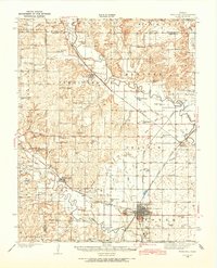 1938 Fredonia1965 Print · USGSSoutheast Kansas in the late thirties is revealed here as a bustling network of rail-side towns and rural school districts. Genealogists can trace family roots through dozens of local landmarks like Caley Cem, Leeper Bridge, and the St Francis Ch.2 unique versions available
 - 1938 Map of Altoona, 1966 Print
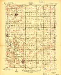
 1938 Altoona1966 Print · USGSSoutheast Kansas in the late thirties was a landscape of dense rural communities and winding river valleys. Researchers can trace family history through dozens of named country schoolhouses like Ninety Nine Sch and Five Mounds Sch, or locate family plots at Buffalo Cem.
 - 1939 Map of Altoona
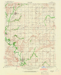
 1939 Altoona1939 Print · USGSSoutheast Kansas is shown at its rural peak in the late thirties, when the Verdigris River valley was dotted with small schoolhouses and family farms. Researchers can locate numerous local landmarks like Sorghum Valley Sch, Buffalo Cem, and the crossing at Barnhill Bridge.
 - 1939 Map of Fredonia
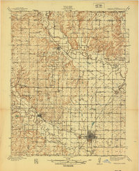 1939 Fredonia1939 Print · USGSThe river valleys of Wilson and Woodson counties are captured here in the late 1930s, showing a landscape defined by agriculture and rail. Genealogists can trace rural family roots through dozens of local school sites like Forty Four Sch and Ten Penny Sch, or the streets of Fredonia and Coyville.2 unique versions available
End of results
Showing maps 1-4 of 4
Top cities of Woodson County
Frequently asked questions
- What are the different types of historical maps available for Woodson County?
- What is the oldest map of Woodson County?
- Where can I purchase historical maps of Woodson County for my home or office?
- Where can I download high-res historical maps of Woodson County?
- Are there historical topographic maps available for Woodson County?
- Is there historical aerial imagery available for Woodson County?
- Where are historical maps of Woodson County sourced from?