1900s (20th Century) Maps of Woodson County, Kansas
Explore 36 historic maps of Woodson County from the 1900s (20th Century). These maps offer a rare glimpse into what life looked like during the 1900s — showing old roads, neighborhoods, homes, and landmarks that have changed or disappeared over time.
Whether you're researching your family's past, planning a metal detecting trip, or studying how Woodson County's landscape evolved across the 1900s, these high-resolution maps are a powerful tool for exploring the history of this region.
- Focus on a specific era: All maps on this page are from the 1900s, giving you a focused view of this time period.
- See what’s changed: Compare century-old streets, trails, and buildings to today's modern landscape using overlays and satellite layers.
- Research with precision: Use these maps for genealogy, historical research, land use analysis, or educational projects.
- View, download, or print: Maps are fully viewable online in high resolution, and can be downloaded or printed for your own records.
Start exploring Woodson County's history through authentic maps from the 1900s. This is your window into the past.
Woodson County, KS maps
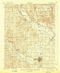
(36)- 1938 Map of Fredonia, 1965 Print
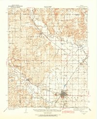 1938 Fredonia1965 Print · USGSSoutheast Kansas in the late thirties is revealed here as a bustling network of rail-side towns and rural school districts. Genealogists can trace family roots through dozens of local landmarks like Caley Cem, Leeper Bridge, and the St Francis Ch.2 unique versions available
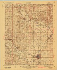
 - 1938 Map of Altoona, 1966 Print
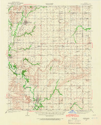 1938 Altoona1966 Print · USGSSoutheast Kansas in the late thirties was a landscape of dense rural communities and winding river valleys. Researchers can trace family history through dozens of named country schoolhouses like Ninety Nine Sch and Five Mounds Sch, or locate family plots at Buffalo Cem.
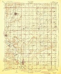
 - 1939 Map of Altoona
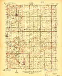 1939 Altoona1939 Print · USGSSoutheast Kansas is shown at its rural peak in the late thirties, when the Verdigris River valley was dotted with small schoolhouses and family farms. Researchers can locate numerous local landmarks like Sorghum Valley Sch, Buffalo Cem, and the crossing at Barnhill Bridge.
 - 1939 Map of Fredonia
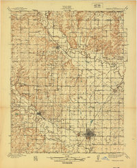 1939 Fredonia1939 Print · USGSThe river valleys of Wilson and Woodson counties are captured here in the late 1930s, showing a landscape defined by agriculture and rail. Genealogists can trace rural family roots through dozens of local school sites like Forty Four Sch and Ten Penny Sch, or the streets of Fredonia and Coyville.2 unique versions available
 - 1942 Map of Fredonia
 1942 Fredonia1942 Print · USGSThe rail crossroads at Fredonia and the winding river valleys of Wilson County are captured here just before the mid-century. Genealogists can trace rural life through dozens of local landmarks like Old Taylor Cem, Coyville, and the Needmore Sch.
 - 1943 Map of Fredonia
 1943 Fredonia1943 Print · USGSSoutheast Kansas at the dawn of the 1940s reveals a landscape of river-valley towns and dozens of rural school districts. Genealogists can trace family footprints through numerous country schools like Ten Penny Sch and the Jackson Cem near New Albany.2 unique versions available
 - 1943 Map of Altoona
 1943 Altoona1943 Print · USGSSoutheast Kansas comes alive in the late thirties as a landscape of river-valley farms and rail-connected towns. Genealogists can trace family roots through an exceptional density of country schools and churches, from Ninety Nine Sch to the Vilas Bethel Ch.2 unique versions available
 - 1947 Map of Lawrence, 1954 Print
 1947 Lawrence1954 Print · USGSEastern Kansas and western Missouri thrive in the late 1940s, showing a landscape defined by major river valleys and a dense railway network. Genealogists can trace family settlements from Lawrence to Greenwood and locate landmarks like Olathe Navy and Lake Lotawana.
 - 1947 Map of Joplin, 1954 Print
 1947 Joplin1954 Print · USGSThe borderlands of Missouri, Kansas, and Oklahoma are shown here during the late 1940s, a period of heavy industrial and military activity. Researchers can trace the extensive Tri-State Mining District, the layout of Camp Crowder, and local landmarks like Mount Hope Cem.
 - 1949 Map of Joplin
 1949 Joplin1949 Print · USGSThe Kansas-Missouri borderlands thrive in the late 1940s, showing a robust network of railroad towns and river valleys. Researchers can trace historic rail lines like the Missouri Pacific RR and locate rural centers such as Chanute, Iola, and Fort Scott.
 - 1950 Map of Lawrence
 1950 Lawrence1950 Print · USGSMid-century Kansas and Missouri come alive in this map of the river-valley corridors just as the interstate era was beginning. Researchers can trace the legacy of major rail lines like the Union Pacific RR and locate ancestral roots in towns from Lawrence to Harrisonville.
 - 1954 Map of Joplin, 1967 Print
 1954 Joplin1967 Print · USGSThe tri-state border region of Kansas, Missouri, and Oklahoma is captured here during a peak era of mid-century industrial and agricultural activity. Researchers can trace family history through dozens of rural cemeteries or locate landmarks like the Kansas Army Ammunition Plant and Pittsburg State University.3 unique versions available
 - 1956 Map of Lawrence, 1967 Print
 1956 Lawrence1967 Print · USGSEastern Kansas and the Missouri border country are captured here during the mid-century transition to the interstate era. Genealogists and local historians can trace family-named terrain like Summers Mound and the footprint of Sunflower Ordnance Works near Baldwin City.4 unique versions available
 - 1958 Map of Joplin
 1958 Joplin1958 Print · USGSThe tri-state border region of Missouri, Kansas, and Oklahoma is shown during the late fifties, a time of heavy rail traffic and mining activity. Local historians can trace the industrial landscape through the Joplin & Pittsburg Ry or locate family sites like Zion Ch and Bender Mounds.
 - 1959 Map of Joplin
 1959 Joplin1959 Print · USGSThe Tri-State region’s mining and rail-driven economy is on full display in the late fifties. Genealogists can locate Lead and Zinc Mines near Joplin, family markers at Oak Hill Cem, and military history at Camp Clark.
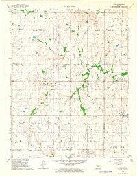
 - 1959 Map of Buffalo, 1960 Print
 1959 Buffalo1960 Print · USGSThe Wilson and Woodson County border comes alive in the late 1950s, showing a landscape defined by rail lines and rural community centers. Trace local roots at Buffalo Cem or follow the legacy of the Missouri Pacific railroad through Buffalo and Roper.2 unique versions available
 - 1961 Map of Lawrence
 1961 Lawrence1961 Print · USGSThe Kansas-Missouri borderland shows its mid-century transition from a rail-dependent agricultural region to a suburbanizing landscape. Genealogists can trace family footprints through numerous Cem sites and distinctive terrain landmarks like Graves Mound and Summers Mound.
 - 1963 Map of Vilas, 1964 Print
 1963 Vilas1964 Print · USGSSoutheast Kansas in the early sixties was a landscape of rail-connected small towns and rural school districts. Genealogists and historians can trace family roots through sites like Vilas, the Vilas Bethel Cem, and the Union Valley Sch.
 - 1967 Map of Gridley SE, 1968 Print
 1967 Gridley SE1968 Print · USGSCoffey and Woodson counties are captured here in the late sixties as the local economy balanced rail transport with oil exploration. Researchers can find old burial grounds like Siria Cem and trace the path of the Atchison Topeka and Santa Fe railroad.
 - 1967 Map of Gridley, 1968 Print
 1967 Gridley1968 Print · USGSGridley and the surrounding Kansas townships are captured here in the late sixties as the local oil industry and rail network shaped the land. Researchers can trace family sites near the Church of the Brethren, explore the Winterscheid Oil Field, or follow the path of the Old Railroad Grade.
 - 1968 Map of Toronto NE, 1969 Print
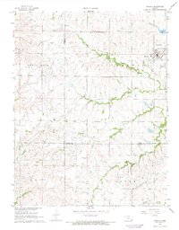
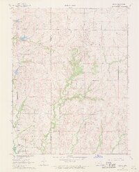
 1968 Toronto NE1969 Print · USGSWoodson County at the end of the 1960s shows a landscape defined by prairie agriculture and active energy extraction. Researchers can locate family landmarks like Nickletown Cem, the Turkey Creek Ch, and the Missouri Pacific rail line.
 - 1968 Map of Rose, 1969 Print
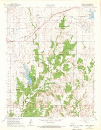
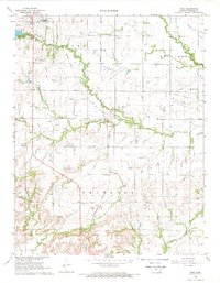 1968 Rose1969 Print · USGSWoodson County in the late sixties shows a landscape of steady agricultural and industrial transition. Researchers can trace the INDIAN TREATY BOUNDARY and locate family history sites like Pleasant Valley Cem and the New York Valley Ch.
 - 1968 Map of Quincy, 1969 Print
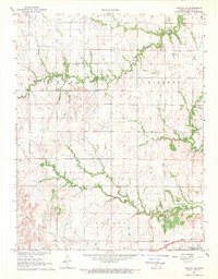
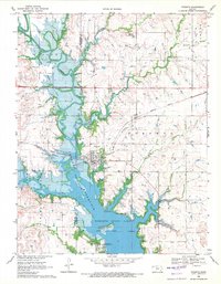
 1968 Quincy1969 Print · USGSWoodson and Greenwood counties are captured here in the late sixties, just as the Toronto Reservoir reshaped the valley. Genealogists and local historians can locate the Quincy Cem and trace the original courses of Dry Creek and Turkey Creek.
 - 1968 Map of Toronto SE, 1969 Print
 1968 Toronto SE1969 Print · USGSWoodson County's rural townships and oil fields are captured here in the late sixties. Researchers can trace the Old Indian Treaty Boundary and locate local landmarks like Belmont Cem and the rail-side settlement of Batesville.
 - 1969 Map of Toronto, 1971 Print
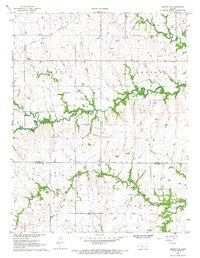
 1969 Toronto1971 Print · USGSNear the Greenwood and Woodson county line in the late 1960s, the Verdigris River valley had newly transformed into a major reservoir system. Genealogists and researchers can trace the Indian Treaty Boundary, the Toronto Cem, and the busy operations of the Quincy Oil Field.
Showing maps 1-25 of 36
Top cities of Woodson County
Frequently asked questions
- What are the different types of historical maps available for Woodson County?
- What is the oldest map of Woodson County?
- Where can I purchase historical maps of Woodson County for my home or office?
- Where can I download high-res historical maps of Woodson County?
- Are there historical topographic maps available for Woodson County?
- Is there historical aerial imagery available for Woodson County?
- Where are historical maps of Woodson County sourced from?