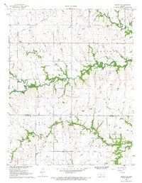
1967 Map of Gridley SE
USGS Topo · Published 1968About this map
The Atchison Topeka and Santa Fe railroad cuts across the northwest corner of this Kansas landscape, reflecting the vital transportation network of the late 1960s. This territory, spanning the border of Coffey and Woodson counties, is defined by the convergence of North Big Creek, South Big Creek, and Big Creek. The map documents a rural economy transitioning between traditional agriculture and early industrial activity, noted by the presence of numerous oil wells near the southern border and several gravel pits scattered near the rail line.
Find a feature on this map
22 named features on this map. Tap any name to fly to it.
Don’t see what you’re looking for? This feature index may not catch every label — zoom into the map to look around manually.
Map Details
Editions of this 1967 Gridley SE Map
This is the sole edition of this map. No revisions or reprints were ever made.
Other maps of this area

1885 · Burlington
USGS Topo · 1:125,000

1886 · Fredonia
USGS Topo · 1:125,000

1894 · Fredonia
USGS Topo · 1:125,000

1894 · Burlington
USGS Topo · 1:125,000

1947 · Lawrence
USGS Topo · 1:250,000

1947 · Joplin
USGS Topo · 1:250,000

1949 · Joplin
USGS Topo · 1:250,000

1950 · Lawrence
USGS Topo · 1:250,000

1954 · Joplin
USGS Topo · 1:250,000

1956 · Lawrence
USGS Topo · 1:250,000