1970s Maps of Calvin, Kentucky
Explore 3 historic maps of Calvin from the 1970s. These maps offer a rare glimpse into what life looked like during the 1970s — showing old roads, neighborhoods, homes, and landmarks that have changed or disappeared over time.
Whether you're researching your family's past, planning a metal detecting trip, or studying how Calvin's landscape evolved across the 1970s, these high-resolution maps are a powerful tool for exploring the history of this region.
- Focus on a specific era: All maps on this page are from the 1970s, giving you a focused view of this time period.
- See what’s changed: Compare century-old streets, trails, and buildings to today's modern landscape using overlays and satellite layers.
- Research with precision: Use these maps for genealogy, historical research, land use analysis, or educational projects.
- View, download, or print: Maps are fully viewable online in high resolution, and can be downloaded or printed for your own records.
Start exploring Calvin's history through authentic maps from the 1970s. This is your window into the past.
Calvin, KY maps
(3)- 1974 Map of Varilla, 1977 Print
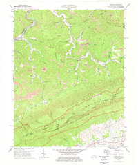 1974 Varilla1977 Print · USGSBell and Harlan counties come alive in the mid-1970s as coal extraction and mountain life intersect near the Virginia border. Genealogists and historians can trace family roots through sites like Varilla Cem, Oakdale Ch, and the remote settlement at Cubage.3 unique versions available
 - 1976 Map of Varilla, 1981 Print
 1976 Varilla1981 Print · USGSBell County, Kentucky, and the Virginia borderlands are captured in this mid-seventies aerial survey at the height of the mountain economy. Researchers can identify homesites and land-clearing patterns near Varilla, Oaks, and along Brownies Creek.
 - 1977 Map of Middlesboro, 1983 Print
 1977 Middlesboro1983 Print · USGSThe tri-state border region of Kentucky, Tennessee, and Virginia is shown here in the late seventies as the rail-and-river economy hummed through the gaps. Trace local family roots and transit routes through Middlesboro, Harlan, and Cumberland Gap National Historical Park.
End of results
Showing maps 1-3 of 3
Top cities near Calvin
- Middlesboro historical maps
- Harrogate historical maps
- Barbourville historical maps
- Pineville historical maps
- Cumberland Gap historical maps
- Ewing historical maps
See more
Frequently asked questions
- What are the different types of historical maps available for Calvin?
- What is the oldest map of Calvin?
- Where can I purchase historical maps of Calvin for my home or office?
- Where can I download high-res historical maps of Calvin?
- Are there historical topographic maps available for Calvin?
- Is there historical aerial imagery available for Calvin?
- Where are historical maps of Calvin sourced from?