1950s Maps of Middlesborough, Kentucky
Explore 8 historic maps of Middlesborough from the 1950s. These maps offer a rare glimpse into what life looked like during the 1950s — showing old roads, neighborhoods, homes, and landmarks that have changed or disappeared over time.
Whether you're researching your family's past, planning a metal detecting trip, or studying how Middlesborough's landscape evolved across the 1950s, these high-resolution maps are a powerful tool for exploring the history of this region.
- Focus on a specific era: All maps on this page are from the 1950s, giving you a focused view of this time period.
- See what’s changed: Compare century-old streets, trails, and buildings to today's modern landscape using overlays and satellite layers.
- Research with precision: Use these maps for genealogy, historical research, land use analysis, or educational projects.
- View, download, or print: Maps are fully viewable online in high resolution, and can be downloaded or printed for your own records.
Start exploring Middlesborough's history through authentic maps from the 1950s. This is your window into the past.
Middlesborough, KY maps
(8)- 1950 Map of Mingo Mountains
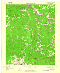
 1950 Mingo Mountains1950 Print · USGSThe Kentucky-Tennessee borderlands appear here at mid-century, capturing the coal-mining settlements and mountain hollows of the Appalachians. Researchers can trace family sites and local landmarks like Rising Spring Church, Manring, and Watson Cem.
 - 1954 Map of Middlesboro North, 1956 Print
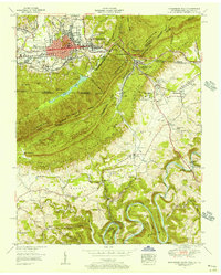
 1954 Middlesboro North1956 Print · USGSThe northern reaches of Middlesboro are shown here in the 1950s, a landscape shaped by coal, timber, and the creation of major parks. Researchers can trace family history at the County Infirmary or locate early rural schools and churches like Fuson Chapel Sch and Yellow Hill Ch.
 - 1955 Map of Johnson City
 1955 Johnson City1955 Print · USGSEast Tennessee and the bordering highlands of Virginia and Kentucky appear here during the post-war industrial boom. You can trace the complex network of mountain ridges and new TVA lakes, from Johnson City to the coalfields near Middlesboro and Lynch.
 - 1955 Map of Middlesboro South, 1956 Print
 1955 Middlesboro South1956 Print · USGSThe tri-state border region comes alive in the mid-fifties, capturing the historic mountain pass and the growing town of Middlesboro. Genealogists can trace family names at Harrogate Cem and Woodson Cem or find old mills such as Minton Mill.
 - 1957 Map of Johnson City, 1966 Print
 1957 Johnson City1966 Print · USGSUpper East Tennessee and Southwest Virginia are shown here during the mid-sixties transition of the Appalachians. Researchers can trace the industrial rail hubs of Kingsport, the sprawling waters of Cherokee Lake, and the historic Cumberland Gap.
 - 1959 Map of Fork Ridge, 1960 Print
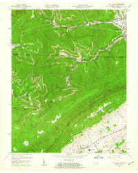 1959 Fork Ridge1960 Print · USGSThe Kentucky and Tennessee borderlands come alive in the late fifties, showcasing a landscape of coal mining and mountain railroading. Genealogists and historians can trace the L & N RR corridor through Middlesboro down to the school and community at Fork Ridge.2 unique versions available
 - 1959 Map of Middlesboro North, 1960 Print
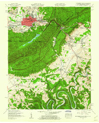
 1959 Middlesboro North1960 Print · USGSMid-century Bell County comes alive in the shadows of the Cumberland ridges just as the local coal and rail industries shaped the landscape. Genealogists can trace family roots through Yellow Hill Cem and Binghamtown, while historians locate landmarks like Wasioto Ch and the old Strip Mines.2 unique versions available
 - 1959 Map of Middlesboro South, 1960 Print
 1959 Middlesboro South1960 Print · USGSThe Cumberland Gap region is captured here in the late fifties, where the historic gateway between Kentucky, Tennessee, and Virginia meets the growing city of Middlesboro. Researchers can locate Lincoln Memorial University, trace the Old Wilderness Road, and find family sites like Hensley Cem or Arthur Sch.2 unique versions available
End of results
Showing maps 1-8 of 8
Top cities near Middlesborough
- Middlesboro historical maps
- Harrogate historical maps
- Barbourville historical maps
- New Tazewell historical maps
- Tazewell historical maps
- Pineville historical maps
See more
Top neighborhoods of Middlesborough
- Noetown historical maps
- Binghamtown historical maps
- Stony Fork Junction historical maps
- Middlesboro historical maps
Frequently asked questions
- What are the different types of historical maps available for Middlesborough?
- What is the oldest map of Middlesborough?
- Where can I purchase historical maps of Middlesborough for my home or office?
- Where can I download high-res historical maps of Middlesborough?
- Are there historical topographic maps available for Middlesborough?
- Is there historical aerial imagery available for Middlesborough?
- Where are historical maps of Middlesborough sourced from?