Old Maps of Lakeshore, Kentucky for Hiking & Exploration
Hike through history with 13 historic maps of Lakeshore. Explore old trails, ghost towns, and forgotten backroads — perfect for outdoor adventurers and local explorers.
- Rediscover forgotten places: Map out old mining camps, roads, and footpaths that no longer exist on modern maps.
- Layer with modern tools: Combine with LiDAR or satellite views to plan hikes through historical terrain.
- Made for exploration: Popular among hikers, overlanders, and local history lovers.
Use these maps to find adventure and explore the hidden past of Lakeshore.
Lakeshore, KY maps
(13)- 1909 Map of Dawson Springs
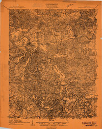 1909 Dawson Springs1909 Print · USGSWestern Kentucky at the peak of its rail-and-river era shows a landscape dotted with country schools and small depots. Genealogists can trace family roots through numerous landmarks like Hamby Sta, Pooles Mill Bridge, and Cross Roads Church.
 - 1911 Map of Dawson Springs
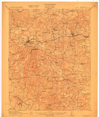 1911 Dawson Springs1911 Print · USGSWestern Kentucky’s coal and rail corridors are captured here just after the turn of the century. Genealogists can trace family footprints through dozens of rural sites like the Daniel Boone School, Franklin's Store, and the Fox Run Mine.2 unique versions available
 - 1954 Map of Evansville
 1954 Evansville1954 Print · USGSThe Ohio River borderlands between Indiana and Kentucky appear here during a period of robust industrial and military growth. Genealogists and researchers can trace the rail corridors of the Illinois Central and find landmarks like US Lock and Dam No 48 or Camp Breckinridge.
 - 1954 Map of Dawson Springs, 1955 Print
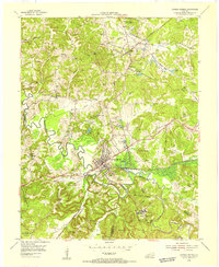 1954 Dawson Springs1955 Print · USGSDawson Springs was a center of coal mining and public health in the mid-1950s. Researchers can trace the legacy of the Dawson Daylight Mine, locate the Outwood Veterans Hospital, and find numerous family burial sites like McNeely Cem.
 - 1957 Map of Evansville, 1969 Print
 1957 Evansville1969 Print · USGSIndiana and Kentucky meet along the Ohio River in this mid-century survey of a vital industrial and transport corridor. Genealogists and historians can trace the development of river towns like Owensboro and Newburgh or locate old rail lines like the Southern Ry.3 unique versions available
 - 1961 Map of Evansville
 1961 Evansville1961 Print · USGSThe Ohio River valley and its surrounding coalfields are captured here during the late fifties and early sixties. Trace the industrial rail networks of the Illinois Central RR and explore regional landmarks like Mammoth Cave National Park and Angel Mounds State Memorial.2 unique versions available
 - 1968 Map of Dawson Springs, 1970 Print
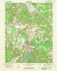 1968 Dawson Springs1970 Print · USGSDawson Springs and the surrounding Kentucky coalfields are shown here in the late sixties as new highways began to reshape the landscape. Local researchers can trace old family names and sites from the Outwood Hospital to rural landmarks like Walnut Grove Ch and Lick Creek Cem.2 unique versions available
 - 1983 Map of Madisonville, 1984 Print
 1983 Madisonville1984 Print · USGSThe Western Kentucky coalfields and river valleys come into focus in the early eighties as the rail-and-river economy matured. Genealogists can trace family footprints across Dawson Springs, Mortons Gap, and Slaughters, or locate landmarks like Shake Rag Hills and Lake Malone.
 - 2010 Map of Dawson Springs, 2010 Print
 2010 Dawson Springs2010 Print · USGSCovers Lakeshore, including Dawson Springs, Charleston, and other nearby areas
 - 2013 Map of Dawson Springs, 2013 Print
 2013 Dawson Springs2013 Print · USGSCovers Lakeshore, including Dawson Springs, Charleston, and other nearby areas
 - 2016 Map of Dawson Springs, 2016 Print
 2016 Dawson Springs2016 Print · USGSCovers Lakeshore, including Dawson Springs, Charleston, and other nearby areas
 - 2019 Map of Dawson Springs, 2019 Print
 2019 Dawson Springs2019 Print · USGSCovers Lakeshore, including Dawson Springs, Charleston, and other nearby areas
 - 2022 Map of Dawson Springs, 2022 Print
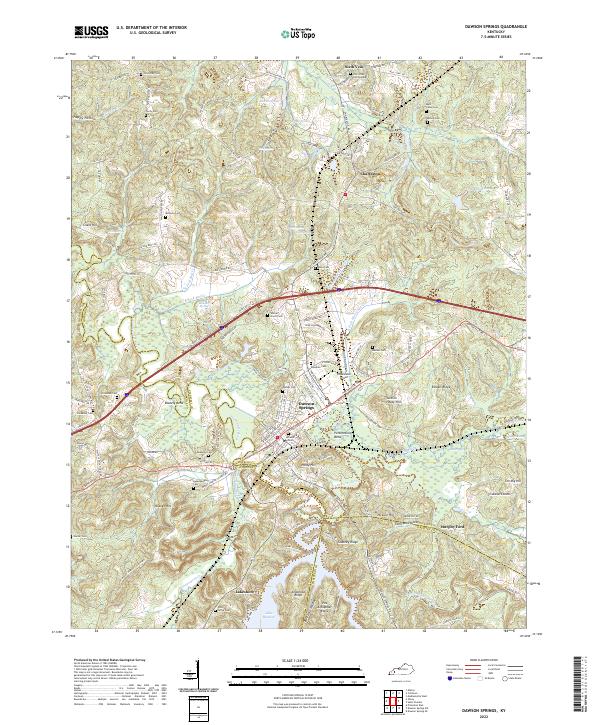 2022 Dawson Springs2022 Print · USGSDawson Springs and the surrounding river valleys are captured here in the early twenty-first century as the region manages its complex water and rail networks. Genealogists can locate numerous family burial sites like Walnut Grove Cem and Piney Grove Cem near the shores of Lake Beshear.
End of results
Showing maps 1-13 of 13
Top cities near Lakeshore
- Madisonville historical maps
- Princeton historical maps
- Dawson Springs historical maps
- Earlington historical maps
- Mortons Gap historical maps
- Crofton historical maps
Frequently asked questions
- What are the different types of historical maps available for Lakeshore?
- What is the oldest map of Lakeshore?
- Where can I purchase historical maps of Lakeshore for my home or office?
- Where can I download high-res historical maps of Lakeshore?
- Are there historical topographic maps available for Lakeshore?
- Is there historical aerial imagery available for Lakeshore?
- Where are historical maps of Lakeshore sourced from?