1900s (20th Century) Maps of Cunningham, Kentucky
Explore 5 historic maps of Cunningham from the 1900s (20th Century). These maps offer a rare glimpse into what life looked like during the 1900s — showing old roads, neighborhoods, homes, and landmarks that have changed or disappeared over time.
Whether you're researching your family's past, planning a metal detecting trip, or studying how Cunningham's landscape evolved across the 1900s, these high-resolution maps are a powerful tool for exploring the history of this region.
- Focus on a specific era: All maps on this page are from the 1900s, giving you a focused view of this time period.
- See what’s changed: Compare century-old streets, trails, and buildings to today's modern landscape using overlays and satellite layers.
- Research with precision: Use these maps for genealogy, historical research, land use analysis, or educational projects.
- View, download, or print: Maps are fully viewable online in high resolution, and can be downloaded or printed for your own records.
Start exploring Cunningham's history through authentic maps from the 1900s. This is your window into the past.
Cunningham, KY maps
(5)- 1951 Map of Blandville, 1952 Print
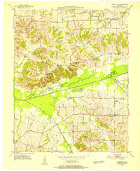 1951 Blandville1952 Print · USGSWestern Kentucky at the dawn of the fifties reveals a landscape of creek-side settlements and family landmarks along the Ballard and Carlisle border. Trace early rural routes to Blandville and Ross Crossing, or locate local burial sites like Hall Cem.2 unique versions available
 - 1952 Map of Fancy Farm, 1958 Print
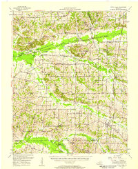 1952 Fancy Farm1958 Print · USGSWestern Kentucky's rural landscapes are documented here in the early fifties, showing the tight-knit farming communities of Graves and Carlisle counties. Trace family history through local landmarks like Fancy Farm, St Charles Sch, and Milburn Cem.
 - 1956 Map of Dyersburg, 1960 Print
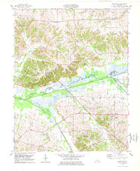
 1956 Dyersburg1960 Print · USGSThe Four Rivers region comes alive in the mid-fifties, capturing the intricate borderlands of Tennessee, Kentucky, and Missouri. Genealogists and historians can trace the rail-and-river networks connecting Dyersburg, Caruthersville, and the shoreline of Reelfoot Lake.4 unique versions available
 - 1977 Map of Blandville
 1977 Blandville1977 Print · USGSWestern Kentucky life in the late seventies centered around the rural crossroads of Ballard and Carlisle counties. Genealogists and local historians can locate several family burial sites like Martin Cem and settlements such as Blandville and New York.
 - 1986 Map of Murray
 1986 Murray1986 Print · USGSWestern Kentucky in the mid-1980s reveals a landscape defined by the Tennessee and Cumberland rivers. Genealogists and historians can trace rail-town development along the Illinois Central Gulf RR and find family-named locations like Dukedom and Water Valley.2 unique versions available
End of results
Showing maps 1-5 of 5
Top cities near Cunningham
- Paducah historical maps
- Mayfield historical maps
- La Center historical maps
- Bardwell historical maps
- Wickliffe historical maps
- Barlow historical maps
See more
Frequently asked questions
- What are the different types of historical maps available for Cunningham?
- What is the oldest map of Cunningham?
- Where can I purchase historical maps of Cunningham for my home or office?
- Where can I download high-res historical maps of Cunningham?
- Are there historical topographic maps available for Cunningham?
- Is there historical aerial imagery available for Cunningham?
- Where are historical maps of Cunningham sourced from?