1900s (20th Century) Maps of Kelly, Kentucky
Explore 7 historic maps of Kelly from the 1900s (20th Century). These maps offer a rare glimpse into what life looked like during the 1900s — showing old roads, neighborhoods, homes, and landmarks that have changed or disappeared over time.
Whether you're researching your family's past, planning a metal detecting trip, or studying how Kelly's landscape evolved across the 1900s, these high-resolution maps are a powerful tool for exploring the history of this region.
- Focus on a specific era: All maps on this page are from the 1900s, giving you a focused view of this time period.
- See what’s changed: Compare century-old streets, trails, and buildings to today's modern landscape using overlays and satellite layers.
- Research with precision: Use these maps for genealogy, historical research, land use analysis, or educational projects.
- View, download, or print: Maps are fully viewable online in high resolution, and can be downloaded or printed for your own records.
Start exploring Kelly's history through authentic maps from the 1900s. This is your window into the past.
Kelly, KY maps
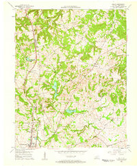
(7)- 1952 Map of Kelly, 1953 Print
 1952 Kelly1953 Print · USGSChristian County's rural landscape is captured here in the early fifties as the Louisville and Nashville railroad serviced local communities like Kelly. Genealogists can trace family roots through several small burial grounds and churches, including Boyd Cem and Wolf Chapel.
 - 1956 Map of Nashville, 1971 Print
 1956 Nashville1971 Print · USGSThe Tennessee-Kentucky borderlands come into focus in the mid-1960s as major reservoir projects transformed the Cumberland and Tennessee river valleys. Researchers can trace the rail networks of the Louisville and Nashville and visit sites like Fort Campbell and Fort Donelson National Military Park.2 unique versions available
 - 1957 Map of Kelly, 1958 Print
 1957 Kelly1958 Print · USGSChristian County's rural landscape in the late fifties shows the shift from northern Hopkinsville into the quiet farming communities of Kelly and Dogwood. Genealogists and historians can trace family burial grounds like Foster Cem and early local landmarks such as Cleveland Spring Ch.
 - 1959 Map of Nashville
 1959 Nashville1959 Print · USGSMiddle Tennessee and Southern Kentucky come into focus during the late fifties, showing the region's transition into a modern transportation and military hub. Researchers can trace the sprawling Fort Campbell Military Reservation or locate historic rail stops along the Tennessee Central Ry and Illinois Central RR.
 - 1969 Map of Kelly, 1971 Print
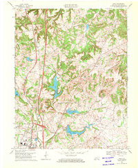 1969 Kelly1971 Print · USGSChristian County near the close of the 1960s shows a landscape of growing infrastructure and rural tradition. Genealogists and researchers can locate old landmarks like Cleveland Spring Ch and the University of Kentucky Community College alongside many family-named roads.2 unique versions available
 - 1980 Map of Hopkinsville, 1983 Print
 1980 Hopkinsville1983 Print · USGSThe Kentucky and Tennessee borderlands appear here at the start of the 1980s, centered on the massive Fort Campbell Military Reservation. Trace the impact of the Cumberland River impoundment at Lake Barkley or locate rail hubs like Guthrie and Elkton.
 - 1993 Map of Kelly, 1996 Print
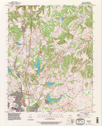 1993 Kelly1996 Print · USGSChristian County in the early nineties shows the northern growth of the county seat against a backdrop of vital water resources. Genealogists and local historians can trace the areas around Kelly, Dogwood, and rural landmarks like Antioch Church and Lake Boxley.
End of results
Showing maps 1-7 of 7
Top cities near Kelly
- Hopkinsville historical maps
- Dawson Springs historical maps
- Nortonville historical maps
- White Plains historical maps
- Crofton historical maps
- Pembroke historical maps
Frequently asked questions
- What are the different types of historical maps available for Kelly?
- What is the oldest map of Kelly?
- Where can I purchase historical maps of Kelly for my home or office?
- Where can I download high-res historical maps of Kelly?
- Are there historical topographic maps available for Kelly?
- Is there historical aerial imagery available for Kelly?
- Where are historical maps of Kelly sourced from?