1950s Maps of L and E Junction, Kentucky
Explore 2 historic maps of L and E Junction from the 1950s. These maps offer a rare glimpse into what life looked like during the 1950s — showing old roads, neighborhoods, homes, and landmarks that have changed or disappeared over time.
Whether you're researching your family's past, planning a metal detecting trip, or studying how L and E Junction's landscape evolved across the 1950s, these high-resolution maps are a powerful tool for exploring the history of this region.
- Focus on a specific era: All maps on this page are from the 1950s, giving you a focused view of this time period.
- See what’s changed: Compare century-old streets, trails, and buildings to today's modern landscape using overlays and satellite layers.
- Research with precision: Use these maps for genealogy, historical research, land use analysis, or educational projects.
- View, download, or print: Maps are fully viewable online in high resolution, and can be downloaded or printed for your own records.
Start exploring L and E Junction's history through authentic maps from the 1950s. This is your window into the past.
L and E Junction, KY maps
(2)- 1952 Map of Sideview, 1954 Print
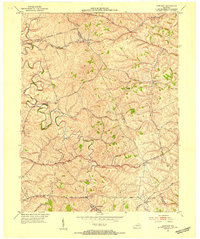 1952 Sideview1954 Print · USGSThe rolling hills of Clark and Montgomery counties are captured in the early fifties, showing a rural landscape of tight-knit communities. Family researchers can trace ancestral locations through names like Mason Cem, Sewell Shop, and Wades Mill.
 - 1956 Map of Louisville, 1971 Print
 1956 Louisville1971 Print · USGSThe Ohio River valley and the Kentucky Bluegrass are captured here during a period of rapid mid-century growth and industrial activity. Genealogists and historians can trace rail-centered towns and military land use at Fort Knox and the Jefferson Proving Ground.2 unique versions available
End of results
Showing maps 1-2 of 2
Top cities near L and E Junction
- Lexington historical maps
- Richmond historical maps
- Winchester historical maps
- Paris historical maps
- Mount Sterling historical maps
- Stanton historical maps
See more
Frequently asked questions
- What are the different types of historical maps available for L and E Junction?
- What is the oldest map of L and E Junction?
- Where can I purchase historical maps of L and E Junction for my home or office?
- Where can I download high-res historical maps of L and E Junction?
- Are there historical topographic maps available for L and E Junction?
- Is there historical aerial imagery available for L and E Junction?
- Where are historical maps of L and E Junction sourced from?